Hurricane Dynamics

Hurricanes are large, swirling storms with winds of 119 kilometers per hour (74 mph) or higher. That's quicker than a cheetah can run which is the fastest animal on land. They are said to be the most violent storms on Earth. These storms are also called by other names, such as typhoons or cyclones, depending on where they occur. The scientific term for these storms is “tropical cyclone.” Only tropical cyclones that form over the Atlantic Ocean or the eastern Pacific Ocean are called "hurricanes”. Whatever they are called, tropical cyclones all form the same way.
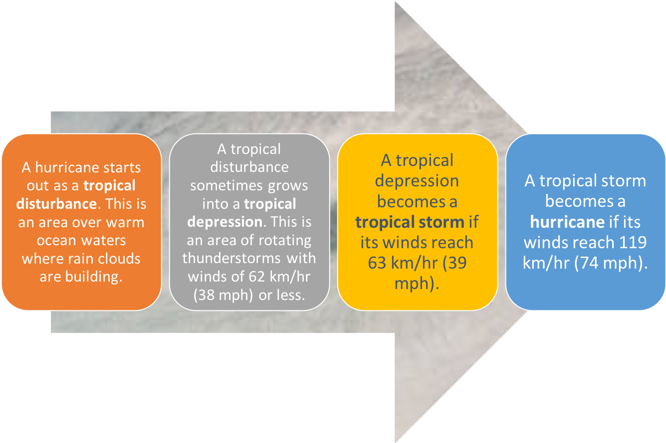
How Does a Storm Become a Hurricane?
When Do They Occur?
Warm ocean waters provide the energy needed for a storm to become a hurricane. Usually, the surface water temperature must be 26 degrees Celsius (79 degrees Fahrenheit) or higher for a hurricane to form.The rate at which wind speed or direction changes with height is called vertical wind shear. Low vertical wind shear - winds that change very little going up through the atmosphere - is needed for hurricane development. High vertical wind shear - winds that are changing significantly with height - tends to rip storms apart.
How do they form? How do warm ocean waters fuel hurricanes?
Scientists don't know exactly why or how a hurricane forms. But they do know that two main ingredients are necessary: warm water and winds that don't change much in speed or direction as they go higher in the atmosphere.
The warm, moist air over the ocean rises upward from near the surface. Because this air moves up and away from the surface, there is less air left near the surface. Another way to say this is that the warm air rises, causing an area of lower air pressure below.
Air from surrounding areas with higher air pressure pushes into the low-pressure area. Then that "new" air becomes warm and moist and rises, too. As the warm air continues to rise, the surrounding air swirls in to take its place. As the warm, moist air rises, the water vapor in the air forms clouds. Forming clouds (condensation) releases heat, which helps the rising air rise further, rising all the way to the top of the troposphere (8.5 miles [14 km] above the surface). The whole system of clouds and wind spins and grows, fed by the ocean's heat and water evaporating from the surface.
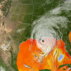
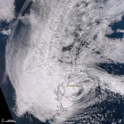
As the storm system rotates faster and faster, an eye forms in the center. It is very calm and clear in the eye, with very low air pressure. Higher pressure air from above flows down into the eye.
What factors influence the strength or intensity of hurricanes?
Like an ice skater whose body spins faster as his arms are drawn inward, air near the surface speeds up as it spirals in towards the center of the low-pressure area. The increasing winds that spin around the center of the storm draw heat and moisture from the warm ocean surface, providing more fuel for the rising motions that produce the clouds.
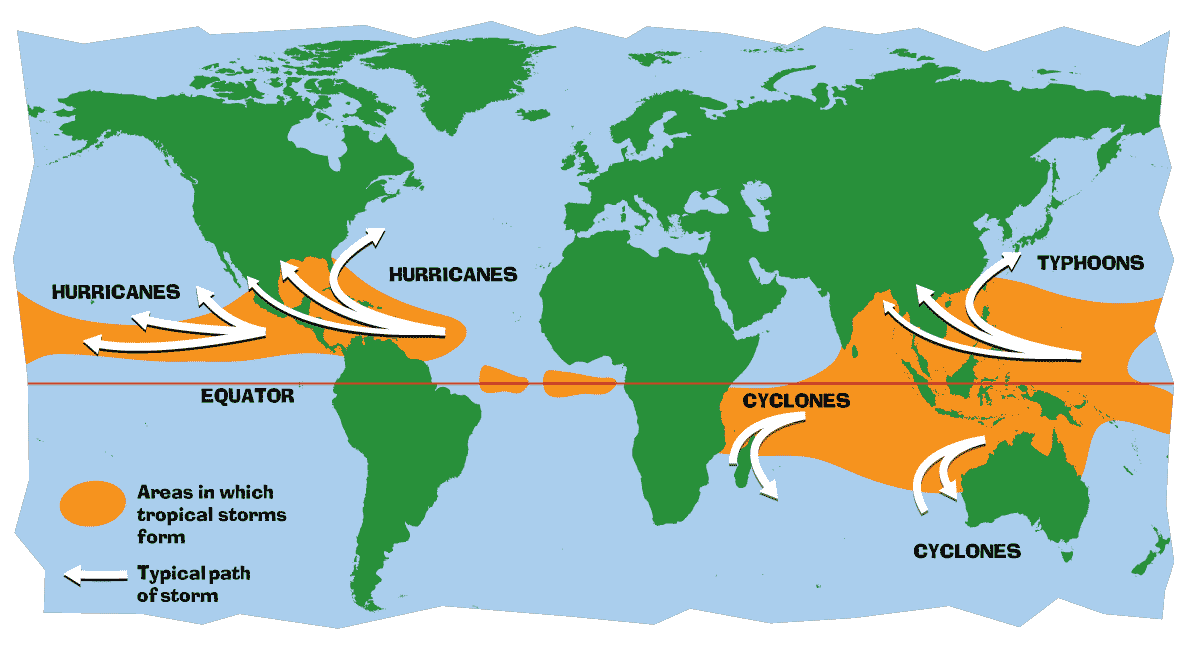
Where Do They Occur?
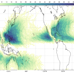
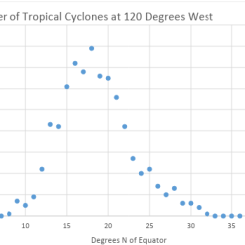
Because tropical cyclones are like giant engines that use warm, moist air as fuel, they form only over warm ocean waters near the equator. The number of hurricanes occurring each year varies widely from ocean to ocean, depending on how much warm ocean water exists. The most active area is the northwestern Pacific Ocean, which contains a wide expanse of warm ocean water. On average, 26 tropical cyclones form in this region each year, of which seventeen reach hurricane (typhoon) status. In contrast, the Atlantic Ocean averages about ten storms annually, of which six reach hurricane status. Compared to the Pacific Ocean, the Atlantic is a much smaller area and therefore supports a smaller expanse of warm ocean water to fuel storms. The Pacific waters also tend to be warmer, and the layer of warm surface waters tends to be deeper than in the Atlantic. Overall, about 80 tropical cyclones occur annually across the globe, one-third of which achieve hurricane status. The frequency and intensity of hurricanes vary significantly from year to year, and scientists haven’t yet figured out all the reasons for the variability.
Tropical cyclones usually weaken when they hit land because they are no longer being "fed" by the energy from the warm ocean waters.
What are the dangers to life and property in a hurricane?
Hurricanes can destroy when reaching land through both wind and water. When a hurricane reaches the coast, it pushes a wall of ocean water ashore. This wall of water is called a storm surge. Along with high waves formed by the strong winds, the storm surge can flood and significantly damage buildings along the coast. Also, slow-moving hurricanes result in heavy rain at the coast and far inland, which can cause flooding in low-lying areas and along rivers.
There is a scale that is used to measure the strength of hurricanes and potential damage. . It is called the Saffir-Simpson Hurricane Scale. A hurricane can be on a scale of one to five. A level one does not destroy as much as a level five does.

Once a hurricane forms, weather forecasters predict its path and how strong it will get. This information helps people prepare for the storm before it arrives, and reduce the threats to life and property.
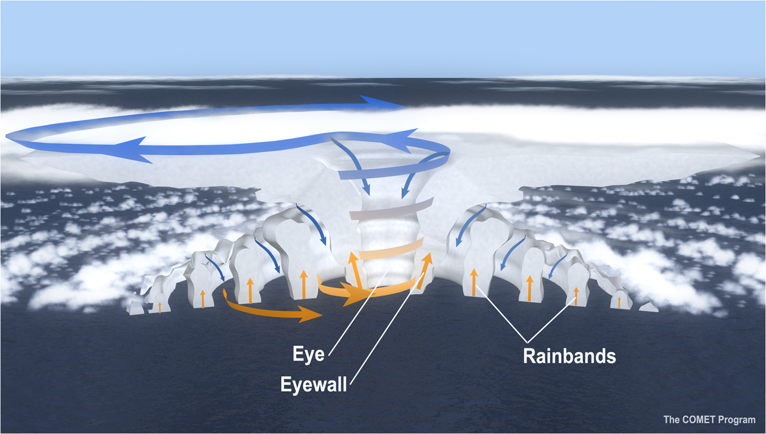 What Are the Parts of a Hurricane?
-
Eye: The eye is the "hole" at the center of the storm. Winds are light and skies are only partly cloudy, sometimes even clear, in this area.
-
Eyewall: The eyewall is a ring of thunderstorms swirling around the eye. The wall is where winds are strongest and rain is heaviest.
-
Rain bands: Spiral bands of clouds, rain, and thunderstorms extend out from a hurricane's eyewall. These bands stretch for hundreds of miles and sometimes contain tornadoes.
Has the frequency and intensity of hurricanes changed over time?
There are four factors that contribute to the birth and growth of a hurricane. They are low pressure, warm temperatures, availability of a warm water source, and tropical wind patterns. Hurricanes have the ability to either grow stronger or weaker, depending on these four factors.
The expected buildup of atmospheric "greenhouse" gases, such as carbon dioxide and methane, will likely increase ocean temperatures as well as the area of ocean surface water warmer than 26°C. It is, therefore, possible that hurricanes will become more frequent and/or more intense in future decades. However, scientists are less sure about how tropical wind patterns will change in the future, and if these changes to the winds will result in hurricanes becoming more intense or frequent.
Why does NASA study hurricanes?
Hurricanes are the most powerful weather event on Earth. NASA’s expertise in space and scientific exploration contributes to essential services provided to the American people by other federal agencies, such as hurricane weather forecasting.
The National Oceanic and Atmospheric Administration and the National Hurricane Center (NHC) use a variety of tools to predict these storms’ paths. These scientists need a wealth of data to accurately forecast hurricanes. NASA satellites, computer modeling, instruments, aircraft and field missions contribute to this mix of information to give scientists a better understanding of these storms.
NASA's Research Role
NASA’s role as a research agency is to bring new types of observational capabilities and analytical tools to learn about the fundamental processes that drive hurricanes and work to help incorporate that data into forecasts. NASA collaborates with its interagency partners so that the nation benefits from our respective capabilities.
“Before we had satellites and aircraft, hurricanes would destroy entire cities, like the Labor Day Hurricane in Key West back in 1935,” said Gail Skofronick-Jackson, the project scientist for NASA’s Global Precipitation Measurement mission at NASA's Goddard Space Flight Center in Greenbelt, Maryland. “You would have no idea if a hurricane was coming until it was too late.”
Hurricanes in the Atlantic Ocean can form when sub-Saharan thunderstorms travel westward with areas of lower pressure. These troughs are known as African Easterly Waves. Warm, moist air rises within the storm clouds, drawing air into the thunderstorms. Like an ice skater pulling in her arms to increase her spin, this inward moving air increases the rotation of the air within the storm cloud. Moving across the warm Atlantic, this cycle repeats on a daily basis, and, with a favorable environment, potentially accelerates to create a monstrous vortex powered by oceanic heat.
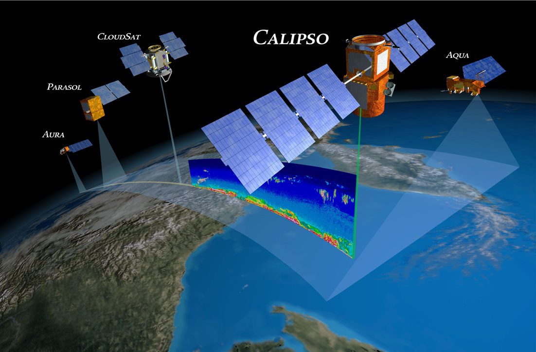
NASA uses an arsenal of instruments to learn more about how these storms progress as they form. These devices orbit Earth on a fleet of spacecraft, including Aqua, Terra, the Global Precipitation Measurement core observatory, NASA-NOAA's Suomi NPP satellite, Calipso, Jason-2 and CloudSat.
“There are typically multiple instruments on every spacecraft with various purposes that often complement each other,” said Eric Moyer, the Earth science operations manager at NASA’s Goddard Space Flight Center in Greenbelt, Maryland. “We can see the progression of a storm from one day to the next using the Terra and Aqua satellites—a morning and afternoon view of every storm system, every day.”
What NASA Studies
These instruments analyze different aspects of these storms, such as rainfall rates, surface wind speed, cloud heights, ocean heat, and environmental temperature and humidity. Observing these factors helps identify the potential for storm formation or intensification. Similarly, the data allows meteorologists to better predict where, when and how hard hurricanes will strike land.
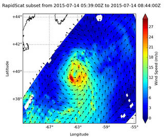
NASA's RapidScat instrument that flies aboard the International Space Station measures surface winds over the ocean and is used to gather data on tropical cyclones. This can show where inside a hurricane the strongest winds occur. RapidScat continues a long satellite record of these observations that began with NASA's QuikScat satellite.
Scientists must completely understand a hurricane to predict its trajectory and strength. This means meteorologists must peer inside the cloud itself.
“Looking at the cloud structure can help us understand the storm’s structure and location, which improves our forecasts,” said Michael Brennan, a senior hurricane specialist at the National Oceanic and Atmospheric Administration’s National Hurricane Center. “We heavily rely on the passive microwave imagers from satellites to see what is happening in the core of the storm.”
Passive microwave imagers aboard NASA’s Global Precipitation Measurement and NASA-NOAA's Suomi National Polar-orbiting Partnership missions can peer through cloud canopies, allowing scientists to observe where the water is churning in the clouds.
“Just like a doctor using x-rays to understand what’s happening in the human body, our radiometers can pierce the clouds and understand the cyclone’s structure,” Skofronick-Jackson said. “We learn about the amount of liquid water and falling snow in the cloud. Then we know how much water may fall out over land and cause floods.”
“Having satellites to watch the oceans is critical, and that will never change,” Skofronick-Jackson said. “Radars on Earth can only see a certain distance out in the ocean, so without spacecraft, you would need radars on every ship. With satellite data informing computer models, we can predict the storms’ paths, to the point where regions only need to evacuate half as much coastline as before. That’s important because it costs a lot of money to pack up, move to a hotel and close down businesses.”
Computer Modeling
Computer modeling is another powerful NASA research tool.
NASA's Global Modeling and Assimilation Office, or GMAO works to improve the understanding of hurricanes and assess models and procedures for quality. GMAO helps to identify information that was missing and determines what services could be added to help future investigation and prediction of hurricane systems.
As NASA launches more sophisticated Earth-observing instruments, teams produce models with higher and higher resolutions, the ability to ingest such data, or the data assimilation procedure, increases. Each new instrument provides scientists and modelers a closer and more varied look at tropical cyclones. The higher the resolution of models and the capability of data assimilation systems, the easier it is to exploit data from satellite-borne instruments and to determine a hurricane’s intensity and size in terms of things such as the wind field and cloud extent.
Airborne Missions
NASA also conducts field missions to study hurricanes. With an arsenal of instruments, ranging from radiometers that read moisture levels; lidars that measure aerosols, moisture, and winds; dropsonde systems to measure high-resolution profiles of temperature, pressure, moisture, and winds; to Doppler radar systems to map the 3-D precipitation and winds within storms. These instruments monitor the structure and environment of hurricanes and tropical storms as they evolve.
The most recent NASA field mission to study hurricanes was the Hurricane and Severe Storm Sentinel or HS3. For three consecutive years, the HS3 mission investigated the processes that underlie hurricane formation and intensity change in the Atlantic Ocean basin. The mission used the Global Hawk, a high-altitude long-endurance aircraft capable of flights of 26 hours at altitudes above 55,000 ft. Flying from the Wallops Flight Facility in Virginia, the uninhabited Global Hawks could cover the entire Atlantic Ocean, enabling measurements of storms at early stages in the central or eastern Atlantic or spending 12-18 hours over storms in the western Atlantic.
A Future Mission
In 2016, NASA launched the Cyclone Global Navigation Satellite System, a constellation of eight small satellites. CYGNSS will probe the inner core of hurricanes in such detail to better understand their rapid intensification. One advantage of CYGNSS is that it can get frequent measurements within storms. This allows CYGNSS to make accurate measurements of ocean surface winds both in and near the eye of the storm throughout the lifecycle of tropical cyclones. The goal is to improve hurricane intensity forecasts.
NASA data and research allows scientists to observe the fundamental processes that drive hurricanes. Meteorologists incorporate this satellite, aircraft and computer modeling data into forecasts in the United States and around the world.
For more on NASA’s hurricane observations and research, visit:
Disciplinary Core Ideas:
Crosscutting Concepts:
- Cause and Effect
- Systems and System Models
- Stability and Change