Lesson Plans
Using Data and Images to Understand Albedo
Overview
Students evaluate graphs and images of sea ice and relate them to changes in albedo. Students make a claim about the interaction of albedo and sea ice extent. This lesson is an updated version of the "Using Data and Images to Understand Albedo Activity" in the GLOBE Earth System Poster Learning Activities Guide.
Materials Required
- Student handouts
Procedure
Introduction
-
Have students compare the two graphs of average monthly temperatures over two years. One is for a location in the Arctic while the other is for a location in the Antarctic. The Arctic graph shows data from the My NASA Data Earth System Data Explorer at 106.5 Degrees West and 67.5 Degrees North and the years 2003-2004. The Antarctic graph shows data from Escuela Provincial No. 38 Presidente Raúl Ricardo Alfonsín, a GLOBE school in Esperanza, Antarctica located at 56.98 Degrees West and 63.4 Degrees South.
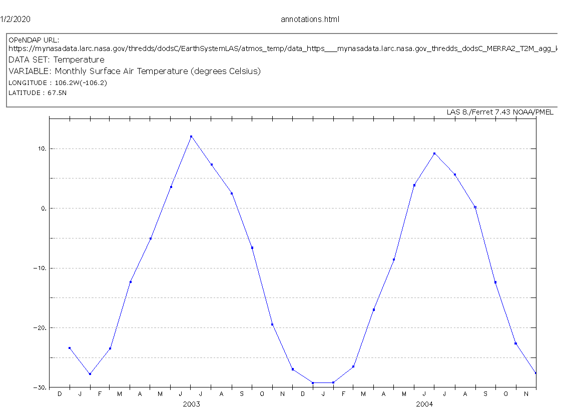
NASA Earth System Data Explorer Average Monthly Temperatures - Arctic - 2003 through 2004 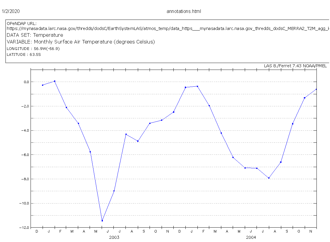
NASA Earth System Data Explorer Average Monthly Temperatures - Antarctic - 2003 through 2004 - Have students explore patterns in these data. (Students should see inverse, or opposite, patterns in the temperature data. For example, the Antarctic is colder in July while the Arctic is warmer in July, etc.)
- Have students discuss processes which explain the patterns in these data. (Students should identify seasonal patterns connected to solar energy and the angle of the Sun throughout the year.)
- Ask students what they think happens to sea ice during these different seasons in these two areas. (It melts and freezes based upon temperatures.)
Discuss Sea Ice
- Show students the following video from NASA's Goddard Space Flight Center.
-
As the video showed, Arctic sea ice reaches its minimum each September. This graph shows the average monthly Arctic sea ice extent each September since 1979, derived from satellite observations. Answer the following questions about the graph.
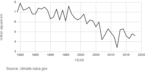
Average Annual September Sea Ice Extent - Credit: NSIDC/NASA - Answer the following questions about the graph.
- Which year has had the lowest recorded Arctic sea ice? (2012)
- Which year had the highest recorded Arctic sea ice? (1980)
- What is the overall trend in annual Arctic sea ice minimum? (It is declining.)
Note: According to climate.nasa.gov, Arctic sea ice is now declining at a rate of 12.8 percent per decade, relative to the 1981 to 2010 average.
“Arctic Sea Ice Minimum | NASA Global Climate Change.” NASA, NASA, 24 Apr. 2019, https://climate.nasa.gov/vital-signs/arctic-sea-ice/.
Access National Snow and Ice Data Center Data
The National Snow and Ice Data Center Distributed Active Archive Center (DAAC)
-
Have students read about sea ice on this National Snow and Ice Data Center All About Sea Ice page.
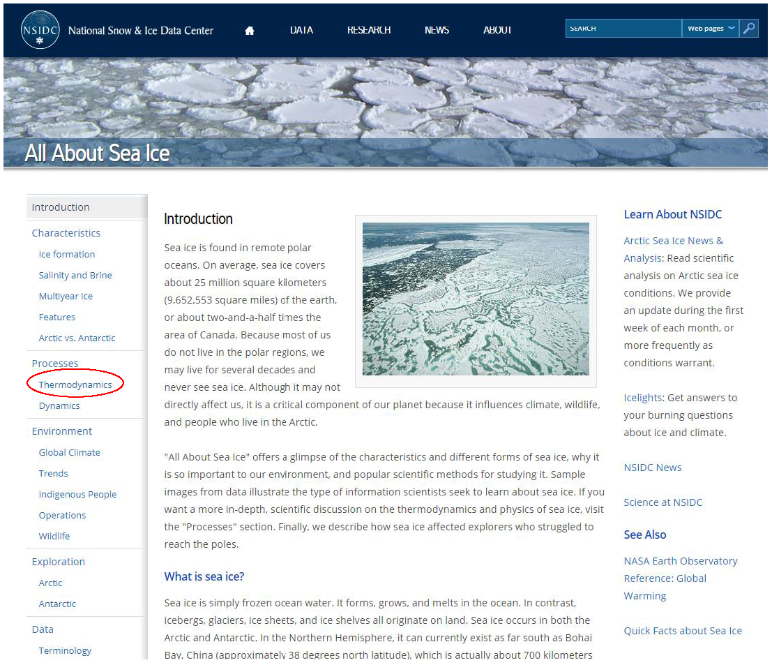
National Snow and Ice Data Center About Sea Ice - “National Snow and Ice Data Center.” All About Sea Ice | National Snow and Ice Data Center, https://nsidc.org/cryosphere/seaice/index.html. -
After reading the introduction on sea ice, have students select Thermodynamics (as shown above by the red oval) under the Processes on the left side of the screen. They will be taken to a screen with 5 tabs. Have students explore the five tabs and answer the following questions for the different tabs.
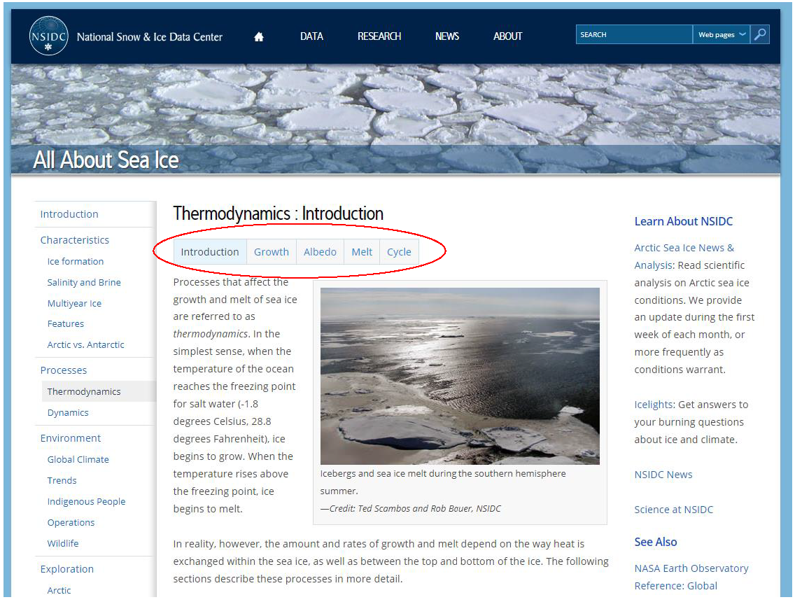
“National Snow and Ice Data Center.” Thermodynamics : Introduction | National Snow and Ice Data Center, https://nsidc.org/cryosphere/seaice/processes/thermodynamics.html. - Introduction
- What are the processes that affect the growth and melt of sea ice called? (thermodynamics)
- What is the freezing point for salt water? (-1.8 degrees Celsius or 28.8 degrees Fahrenheit)
- Other than temperature, what else do the growth and melting rates depend upon? (The way heat is exchanged within the sea ice, as well as between the top and bottom of the ice.)
- Growth
- Why does more than just the ocean surface need to reach the freezing point for ice to form? (As the ocean temperature nears the freezing point, water density increases and cold water sinks. Warmer water replaces it and must be cooled.)
- How does the formation of ice slow the growth of ice? (Ice acts as an insulator and slows the conduction of heat from the ocean through the ice making it take longer for the water below the ice to reach the freezing point.)
- How does snow cover slow the growth of ice? (Snow also acts as an insulator and slows the transfer of heat from the ocean. This makes it take longer for the water below the ice to reach the freezing point.)
- Albedo
- What is albedo? (Albedo is a quantity with no unit that indicates how well a surface reflects solar energy. Valid values are between 0 and 1 with 0 being a surface that absorbs all solar energy and 1 being a surface the reflects all solar energy.)
- What happens when a surface absorbs the light? (The surface can heat up. In the case of ice, it can melt.)
- How does the albedo of sea ice compare with that of the ocean? (It is much higher meaning that it reflects more solar energy.)
- What is the typical ocean albedo? (0.06 - It only reflects only 6% of the solar energy.)
- What is the typical sea ice albedo? (0.5 to 0.7 - It reflects 50% to 70% of the solar energy.)
- How does the high albedo of the sea ice affect the surface? (It keeps it cooler because it absorbs less solar energy.)
- What is the albedo of snow? (up to 0.9 - It can reflect up to 90% of the solar energy.)
- How does the snow delay ice melt in the summer? (It insulates the sea ice, and it reflects much of the solar energy.)
- What happens when the snow does begin to melt? (Shallow melt ponds form and have a much lower albedo. This leads to higher energy absorption and more rapid ice melt.)
- Melt
- What are some sources of energy for ice melt other than solar energy? (Water under the ice that is above the freezing point can melt the bottom of the ice. Warm surface waters can melt the edges of the ice.)
- Which of the items shown in the illustration has the highest albedo? (snow)
- Which of the items shown in the illustration has the lowest albedo? (open ocean)
- Cycle
- Describe the growth and melt cycle of sea ice. (Sea ice grows in the autumn and winter and becomes thicker. In the spring and summer, the ice begins to melt. Some of it will melt completely, and some will not. The ice that does not melt completely will grow thicker the next year during the growth period.)
- Can ice get thicker indefinitely? (No, it will reach thermodynamic equilibrium. This means that the ice is thick enough to prevent the heat from leaving the ocean, and the ocean will not reach the freezing point.)
- What is the thermodynamic equilibrium thickness of sea ice in the Arctic? (Approximately 3 meters, but it can go as high as 10 meters or more.)
- What is the thermodynamic equilibrium thickness of sea ice in the Antarctic? (1 to 2 meters)
- Introduction
- Evaluate Sea Ice Images
- Go to the National Snow and Ice Data Center Browse Image Spreadsheet Tool.
- Select Sea Ice Index: Extent, Concentration, and Concentration Anomalies from the dropdown menu.
- Change the top set of controls as follows. (See the figure below.)
- Change Scale to 75%
- Click on the first Month dropdown menu and change it to Feb.
- Click on the first Map dropdown menu and change it to Sea Ice Extent if it is not already indicated.
- Click on the second Month dropdown menu and change it to Aug.
- Click on the second Map dropdown menu and change it to Sea Ice Extent if it is not already indicated.
- Click on the top Year dropdown menu and change it to 1988.
- Click on the bottom Year dropdown menu and change it to 2018.
- Click on the Refresh button. Browse Image Subset Tool - https://nsidc.org/data/seaice_index/bist
- The following images should appear.
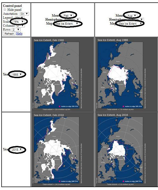
Answer the questions about the images.
- How do the months of February and August compare in 1988? (August has less sea ice than February.)
- How do the months of February and August compare in 2018? (August has less sea ice than February.)
- What can you conclude about the differences between February and August in general? (Summer will have less ice than winter.)
- How does February 1988 compare with February 2018? (There was more sea ice in February 1988 than in February 2018.)
- How does August 1988 compare with August 2018? (There was more sea ice in August 1988 than in August 2018.)
- Using the images and the graph you looked at before, what can you conclude about the trends in sea ice over time? (The overall sea ice is decreasing across seasons.)
- What role does albedo play in the changes in sea ice? (As albedo is reduced, more energy from the Sun is captured leading to higher temperatures which reduce the formation of sea ice and cause more ice melt.)
-
Make a claim about the future trends in sea ice using the evidence you examined in this activity. (Accept reasonable responses.)
Supported NGSS Performance Expectations
- Evaluate and interpret data in a variety of formats related to albedo of sea ice and how it changes over time.
- Explain the effect of changing albedo on sea ice extent.
How does the albedo of sea ice and snow impact its growth and melt cycle?
This video explains albedo - the concept that the brightness of the Earth system (atmosphere, ocean, land surfaces) determines how much incoming solar energy is immediately reflected back to space. Reflected shortwave energy and land albedo products demonstrate the seasonal and geographic variability of this critical climate process. For more information, visit http://climatebits.org
- Understanding of the seasonal changes of sea ice
- Ability to manipulate the Earth System Data Explorer data visualization tool
Students may not be aware of the following:
- Ice and snow can act as insulators.
- The freezing point of salt water is below zero degrees Celsius.
- Sea ice has a growth and melt cycle.
Measuring Albedo
This video describes how and why NASA studies Earth's energy budget.
Sunlight is the primary driver of Earth’s climate and weather. Averaged over the entire planet, roughly 340 watts per square meter of energy from the Sun reach Earth. About one-third of that energy is reflected back into space, and the remaining 240 watts per square meter is absorbed by land, ocean, and atmosphere. Exactly how much sunlight is absorbed depends on the reflectivity of the atmosphere and the surface.
As scientists work to understand why global temperatures are rising and how carbon dioxide and other greenhouse gases are changing the climate system, they have been auditing Earth’s energy budget. Is more energy being absorbed by Earth than is being lost to space? If so, what happens to the excess energy?
For seventeen years, scientists have been examining this balance sheet with a series of space-based sensors known as Clouds and the Earth’s Radiant Energy System, or CERES. The instruments use scanning radiometers to measure both the shortwave solar energy reflected by the planet (albedo) and the longwave thermal energy emitted by it. The first CERES went into space in 1997 on the Tropical Rainfall Measuring Mission, and three more have gone up on Terra, Aqua, and Suomi-NPP. The last remaining CERES instrument will fly on the JPSS-1 satellite, and a follow-on, the Radiation Budget Instrument (RBI), will fly on JPSS-2.
If Earth was completely covered in ice, its albedo would be about 0.84, meaning it would reflect most (84 percent) of the sunlight that hit it. On the other hand, if Earth was covered by a dark green forest canopy, the albedo would be about 0.14 (most of the sunlight would get absorbed). Changes in ice cover, cloudiness, airborne pollution, or land cover (from forest to farmland, for instance) all have subtle effects on global albedo. Using satellite measurements accumulated since the late 1970s, scientists estimate Earth’s average albedo is about about 0.30.
In the early 2000s, after the first few years of Terra-CERES measurements, it appeared that Earth’s albedo was declining, a phenomenon that was widely reported in scientific journals and on NASA Earth Observatory. But as more years of data accumulated, and as scientists began to better understand the data, they found that albedo was neither increasing nor declining over time. It was fluctuating a lot by year, though.
“What the results show is that even at global scales, Earth’s albedo fluctuates markedly over short time periods due to natural variations in the climate system,” said Norman Loeb, CERES principal investigator at NASA’s Langley Research Center. Ice cover, cloud cover, and the amount of airborne particles—aerosols from pollution, volcanoes, and dust storms—can change reflectivity on scales from days to years. “We should not get fooled by short-term fluctuations in the data, as a longer record may reverse any short-term trend.”
“The results also suggest that in order to confidently detect changes in Earth’s albedo above natural variability, a much longer record is needed,” Loeb added. “It is paramount that we continue the CERES Terra, Aqua, and Suomi-NPP observations as long as possible, and launch follow-on Earth radiation budget instruments to ensure continued coverage of this fundamental property of the climate system.”
https://earthobservatory.nasa.gov/images/84499/measuring-earths-albedo
Atmospheric Scientist - Atmospheric scientists study the weather and climate and examine how those conditions affect human activity and the earth in general. Most atmospheric scientists work indoors in weather stations, offices, or laboratories. Occasionally, they do fieldwork, which means working outdoors to examine the weather. Some atmospheric scientists may have to work extended hours during weather emergencies.
Data Visualization - At the core of scientific visualization is the representation of data graphically - through images, animations, and videos - to improve understanding and develop insight. Data visualizers develop data-driven images, maps, and visualizations from information collected by Earth-observing satellites, airborne missions, and ground measurements. Visualizations allow us to explore data, phenomena and behavior; they are particularly effective for showing large scales of time and space, and "invisible" processes (e.g. flows of energy and matter) as integral parts of the models.
Glaciologist - Glaciology is the study of snow and ice. A glaciologist is one who studies and analyzes the movement and physical properties of glaciers and ice. Glaciologists research characteristics of the Cryosphere that include formation, movement, and effects of other parts of the Earth System. A characteristic of their research is to analyze how glaciers and ice caps move and change due to climate change and how those changes influence the climate and surrounding environment.
Model Analyst - A model analyst develops models to help visualize, observe, and predict complicated data. Model analysis is the process of taking large amounts of data and separate it into a structure that makes it intelligible to the binary process of computers. An analyst also manages the flow of information between different user groups through the use of relational databases.
- Compare NSIDC images for different years.
- Find the minimum sea ice extent images from NSIDC.
- Compare temperature graphs with GLOBE Earth System Poster activity insolation cards.
- Internet Required
- One-to-a-Group
- Visualization Tool Required
Complementary Lesson Plans
Complementary Pages


Grade Band
- 6-8
- 9-12
Time
- 90 minutes
My NASA Data Visualization Tool
Related Resources
- Changing Albedo and Sea Ice
- Changing Albedo Lab
- Does Albedo Effect Arctic Populations?
- GLOBE Digital Earth System Poster
- Explore Albedo Values
- GLOBE Earth System Poster Activity Guide
- Positive Feedback - Arctic Albedo
- Sea Ice and the Earth System Story Map
- Seasonal Arctic Albedo
- Instructional Strategies for the Earth Science Classroom