Mini Lesson/Activity
Analyzing Earth’s Energy Imbalance by Latitude and Month
Overview
Students will analyze a graph showing the variation of energy imbalance on Earth over the year along different latitudinal zones and answer the questions that follow.
Student Directions
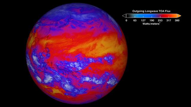
Earth's climate is a delicate balance between how much of the Sun's energy absorbs into the atmosphere and at the surface, and how much of that energy is emitted back into space in the form of thermal infrared radiation. This difference is known as the Earth's Energy Imbalance (EEI). Increasing emissions of greenhouse gases, such as carbon dioxide and methane due to human activity for example, can have an increasing effect on this imbalance and can drive further warming of Earth's temperatures.
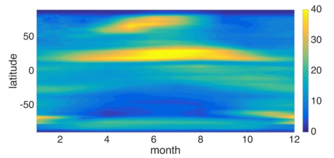
Data taken from NASA's CERES instrument shows the average imbalance of energy in the Earth System. The chart shows latitudinal zonal bands per month from 2000-2017. Use the latitudinal map provided as a guide to analyzing this chart and answer the following questions.
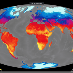
Recall that lines of latitude are the angular measurements of north-south location on Earth and that these horizontal lines range from 90° South (at the South pole), 0° (all along the equator), to 90° North (at the North pole).
Review the map below which shows groups of latitudes that are referred to as zones; they include:
- The Arctic Zone (90.0°N - 64.2°N)
- The N. Mid-Latitude Zone (64.2°N - 23.5°N)
- The Tropic Zone (between 23.5°N and 23.5°S)
- The S. Mid-Latitude Zone (23.5°S - 64.2°S)
- The Antarctic Zone (64.2°S - 90.0°S)
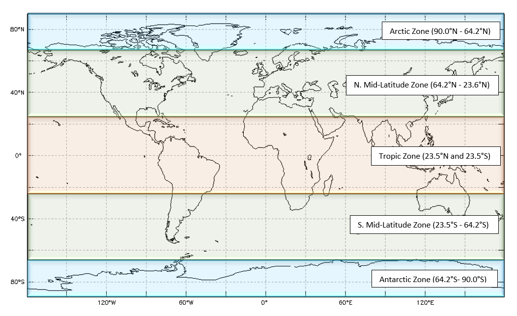
https://mynasadata.larc.nasa.gov/sites/default/files/inline-images/Latzones.png
Steps:
- Check with your instructor on how to submit your answers.
- Describe the latitude zone/s where you see the biggest range in values. Why do you think this is?
- What months do you observe the greatest change by latitude?
- What zones change the least? Why do you think this is?
Sources:
- M. Z. Hakuba et al., "Earth’s Energy Imbalance Measured From Space," in IEEE Transactions on Geoscience and Remote Sensing, vol. 57, no. 1, pp. 32-45, Jan. 2019, doi: 10.1109/TGRS.2018.2851976.
Teacher Note
Teachers, these mini lessons/student activities are perfect "warm up" tasks that can be used as a hook, bell ringer, exit slip, etc. They take less than a class period to complete. Learn more on the "My NASA Data What are Mini Lessons?" page.
Teachers who are interested in receiving the answer key, please complete the Teacher Key Request and Verification Form. We verify that requestors are teachers prior to sending access to the answer keys as we’ve had many students try to pass as teachers to gain access.
Disciplinary Core Ideas:
- ESS2A: Earth Materials and Systems
- ESS3D: Global Climate Change
Crosscutting Concepts:
- Patterns
- Stability and Change
Science and Engineering Practices:
- Developing and Using Models
- Analyzing and Interpreting Data
Complementary Mini Lessons
Complementary Interactives

Document Resources
Grade Band
- 9-12
Time
- 15 minutes
Visualization Tool
NGSS Three Dimensional Learning
- See drop-down menu at the bottom of the page