Lesson Plans
Where in the world are major environmental changes?
Overview
This investigation introduces students to the significant environmental changes occurring around the world. The investigation uses NASA satellite images of Brazil to illustrate deforestation as one type of environmental change. Students learn that satellite images provide useful information to interpret, understand, plan, and predict environmental changes.
Materials Required
 Briefing and Logs 1, 2, and 3 (one of each per student)
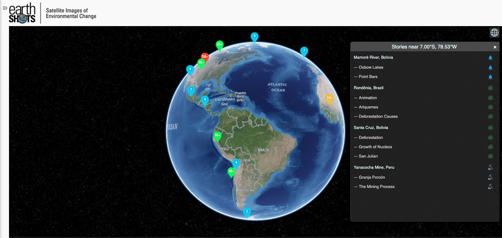
- Images of environmental change - USGS Earth Shots
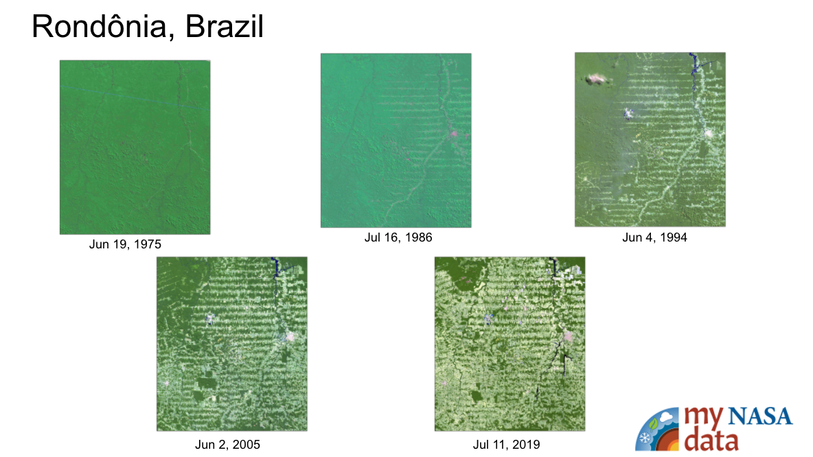
- See Rondonia in card deck to show Images of forests in Brazil
- World atlases
- Outline maps of the world
- Poster paper for display of group work
Procedure
Beginning the Investigation
1. Have students develop a list of topics that NASA scientists study. Share the list with the class. Discuss the topics presented and have students identify which topics are local issues and which are global issues.
2. Using the class discussion as a starting point, explain to students that NASA scientists study many topics and use photos and data gathered by airplanes as well as images and data gathered by satellites.
3. Distribute and have students read the Briefing.
4. Divide the class into groups of 3–4 students. Each group should have a recorder/reporter. Explain to students that some environmental changes negatively affect a large proportion of Earth’s population, influence large areas of Earth, endure for a long time, and require the cooperation of many societies to solve or improve. If possible, have students explore the Earthshots website on environmental change.
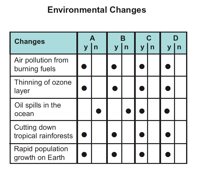
5. Distribute Log 1. Ask students to identify, list, and discuss issues that they believe are major environmental changes. Responses may include: global warming, ozone depletion, removal of rainforests, water pollution, air pollution, loss of land to city expansion, rapid population growth, and resource depletion. Ask students to consider the advantages and disadvantages of the environmental changes to human populations in the affected areas. Ask them to refine their lists by evaluating each major environmental change with respect to the following four traits:
- the portion of the world’s population involved in the change,
- the area of Earth influenced by the change,
- the length of time that the effects endure, and
- the number of countries required to solve or improve the conditions related to the change.
6. Group recorders report to the entire class the results of the small-group discussions, and the whole class compiles a comprehensive list of global/major environmental issues. These could be displayed for future reference.
Developing the Investigation
7. Ask each group of students to use world atlases and outline maps of the world to locate where each environmental change they identified is occurring. A change may be occurring in one or several locations. For example, a major earthquake may occur at a single location, whereas a severe drought may affect many countries.
Using the atlases, students should give the latitude and longitude of the locations and a brief description of the physical characteristics of the regions where the environmental changes are occurring. Some changes will be more difficult to pinpoint than others. For example, warming of Earth’s atmosphere may occur nearly everywhere rather than at just one or a few locations.
8. Distribute Log 2. Explain that human activities fulfill basic needs and have intended and unintended consequences on natural environments. For example, cutting portions of tropical rainforests to obtain valuable wood for export and clearing land for cattle grazing and settlements may have intended consequences of creating wealth for lumber companies and livestock owners and of offering places to live for migrating people. On the other hand, unintended consequences may include destroying species of wildlife dependent on the rainforest and altering climate in the region.
Concluding the Investigation
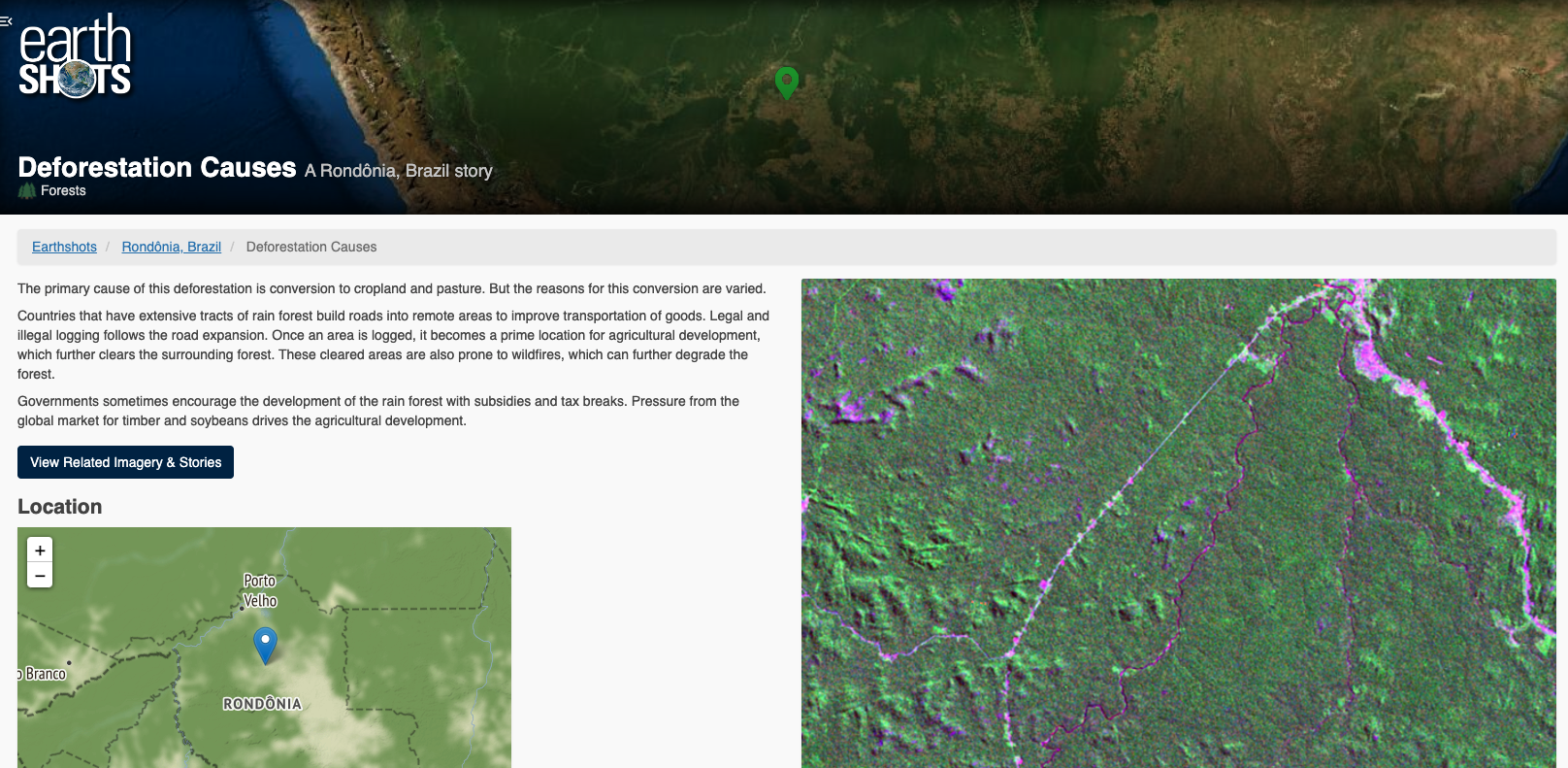
9. Distribute Log 3. Students have thought about environmental problems based on prior knowledge and class discussion, and they have mapped the problems they identified. Example, tropical rainforest destruction is a major environmental change. Images include selections from this link depicting Rondonia, Brazil. Students may use the Earthshot card for Rondonia as an option if access to technology is an issue.
|
 |
Evaluation
- Log 1 - Students will add issues to the Environmental Changes Checklist that they identify as major environmental changes. The issues on the checklist will vary among students. The following is a sample of some possible environmental changes.
- Log 2 - Students develop their own answers to questions concerning basic human material needs. For example in Question 1, “What are the basic material needs that all people have?” Students could answer, “Food, shelter, and water” or “Hamburgers, french fries, and milkshakes.” Any answers that they provide should then be used to complete the remaining questions. Students should not be expected to have identical answers.
- Log 3:
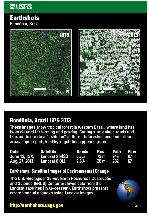
1. In the 1992 image, there are more settlements than in 1975, as shown by the increase in blue areas. Light red streaks are apparent in the 1992 image but not in the 1975 image, indicating deforestation.
2. The pattern of deforestation in the 1992 image is in long, narrow lines that stay about the same distance apart all along the length of the lines. This is a fishbone pattern.
3. Valuable species of trees are cut and sold by commercial loggers. The remaining trees and vegetation are often burned, clearing land for growing crops, raising livestock, and building houses and stores.
4. Animals that need large expanses of forest to live may be at a disadvantage as the forest is broken up into long, parallel strips. They may be forced to remaining parts of the forest to search for food and shelter, or they may become endangered or extinct.
5. One pattern that might preserve large areas of forest is a hub and spoke pattern similar to a wagon wheel. A central settlement with roads running out in different directions might preserve large areas of land for wildlife that would remain connected to the whole forest. Students may suggest other patterns.
6. The pattern suggested in Question 5 might be better than the pattern in the 1992 image because it would preserve large areas of forest while still allowing new settlement and tree cutting.
7. Deforestation in Rondonia affects other places. For example, trees are sold to make products sold in other locations. People who settle in the newly cleared forest come from other places. Also, extensive deforestation and burning causes changes in atmospheric gases such as carbon dioxide. Loss of plant species that may have had medicinal benefits also occurs.
8. People might make products from materials in the forest without cutting the trees or they might grow crops that require less tree removal.
Concluding Activity
Sample ideas for short essay topics:
- Advantages: More space for humans to live, income from farming or mining cleared land, income from selling valuable trees
- Disadvantages: Species of plants and animals may decline or become extinct, harmful changes might occur in atmospheric gases
Disciplinary Core Ideas:
- ESS3C: Human Impacts on Earth Systems
Crosscutting Concepts:
- Cause and Effect
- Scale, Proportion, and Quantity
- Stability and Change
Science and Engineering Practices:
- Asking Questions and Defining Problems
- Analyzing and Interpreting Data
In this investigation, students will:
- describe several major environmental changes,
- locate places in the world where major environmental changes are occurring,
- give reasons why an environmental change may be classified as major,
- describe issues related to deforestation in a tropical region,
- offer ways to remedy some of the negative consequences of deforestation,
- describe features on thermal images, and
- explain why NASA scientists study environmental changes.
- How does the environment change in short and long time periods? Over small and large scales?
- Where do major environmental changes occur?
- What effect does deforestation have on the Earth System?
- How is deforestation monitored?
- What can be done to reduce the impacts of deforestation?
Many environmental changes are interconnected on a global scale. For example diseases that originate in one place may threaten populations in other places as people migrate from region to region. Also, unusual climate and weather conditions may destroy crops in one country and create bumper crops in another country. Serious food shortages may occur in one place and surpluses in another. Moving food over long distances may be required to avoid starvation and malnutrition. NASA scientists are interested in monitoring environmental changes on Earth’s surface so that their consequences can be understood and predicted. Environmental changes often affect human well-being.
Human activities on Earth’s surface have intended and unintended consequences. For example, cutting portions of tropical rainforests to obtain valuable wood for export to other countries, clearing land for cattle grazing, and settlements may result in creating wealth for lumber companies and livestock owners and in providing places to live for migrating people. Unintended consequences may include destroying species of wildlife dependent on the rainforest and altering Earth’s climate. Unintended consequences may not be understood in time to repair the negative environmental changes.
To survive people depend on the physical environment. They adapt to it and modify it to suit their changing needs for things such as food, clothing, water, shelter, energy, and recreational facilities. In meeting their needs, they bring knowledge and technology to bear on physical systems. Clearing land for settlement, mining, and agriculture provides homes and livelihoods for some but alters physical systems and transforms human populations, wildlife, and vegetation.
Tropical Deforestation in Rondonia, Brazil
Approximately 39 percent (5,200,000 square kilometers) of the world’s tropical forests are in Brazil. The estimated average deforestation rate of the tropical forest in Brazil and other parts of the Amazon in 1990 to 2000 was 3,847 square kilometers per year. Systematic cutting of forest vegetation starts along roads and then fans out to create the “feather” or “fishbone” pattern. The deforested land and urban areas appear in light blue; healthy vegetation appears red.
In Rondonia the forests are a resource for commercial logging. Valuable trees are cut and sold. Remaining trees may be burned along with other vegetation. Commercial cattle raising and farm settlements are other important reasons for deforestation in tropical rainforests. As the trees and other vegetation are removed, wildlife habitat is destroyed. Sometimes isolated forest parcels are left by deforestation, causing plants and animals to be cut off from the larger forest area. Large-scale forest removal threatens species and alters climate characteristics.
When land in Rondonia was opened for development by building a road through the forest, many settlers carved through the forest along regularly spaced, perpendicular roads from the main transportation artery. They created a fishbone pattern of deforestation. The fishbone pattern has the effect of dividing the remaining forest into many small parcels, providing very little undisturbed forest for wildlife in between. What would have happened if a different pattern of clearing had been used such as a hub-and-spoke pattern? If a hub and spoke were used, the undisturbed areas would have been larger and wildlife would have been less threatened by development. If sections were designated as preserves on which no development could occur, the possibility of species preservation would be even greater.
The actual rate of deforestation is difficult to determine and has been the focus of NASA-funded study for many years. NASA projects to investigate the deforestation of tropical forests are conducted by analyzing satellite images to determine the area of forest that has been cleared. <http://www.bsrsi.msu.edu/rfrc/deforestation.html>
Geography Standards
- Standard 4: Places and Regions The physical and human characteristics of places
- Analyze the physical characteristics of places.
- Standard 14: Environment and Society How human actions modify the physical environment
- Analyze the environmental consequences of human changes of the physical environment.
- Standard 15: Environment and Society How physical systems affect human systems
- Analyze ways in which human systems develop in response to conditions in the physical environment.
- Analyze ways in which human systems develop in response to conditions in the physical environment.
- Geography Skills
- Skill Set 1: Ask Geographic Questions
- Identify geographic issues, define geographic problems, and pose geographic questions.
- Skill Set 2: Acquire Geographic Information
- Use maps to collect and/or compile geographic information.
- Skill Set 3: Organize Geographic Information
- Prepare various forms of maps as a means of organizing geographic information.
- Skill Set 4: Analyze Geographic Information
- Interpret information from maps and satellite images.
- Skill Set 5: Answer Geographic Questions
- Make generalizations and assess their validity.
- Skill Set 1: Ask Geographic Questions
Deforestation is a significant environmental change in several regions of the world. Extensive tree removal often results in widespread habitat destruction. Large-scale reductions in vegetation may also lead to climate change. Deforestation in Rondonia, Brazil, as recorded by NASA imagery, provides a useful case study of a major environmental change.
- One-to-a-Group
Complementary Lesson Plans


Grade Band
- 6-8
- 9-12
Time
- > 90 minutes
Visualization Tool
NGSS Three Dimensional Learning
- See drop-down menu at the bottom of the page