Lesson Plans
Investigating Deforestation Through An Earth Systems View Using Landsat
Overview
The purpose of this activity is to have students use an Earth Systems perspective to identify the various causes associated with changes to Earth's forests as they review Landsat imagery of site locations from around the world.
Materials Required
8 (duplexed) Interactive Cards printed in color.
Alternatively, if computers or tablets are available, consider having students use the Google Slide Interactive Card resource with their graphic organizer.
Procedure
- Distribute the Interactive Cards to each group and the graphic organizer to each member. -Alternatively, if you are using the computer option, distribute computers and the URL.
- Direct students to write "Deforestation" in the center block on the organizer. Students will review the images to find contributing factors leading to deforestation and document their findings on the organizer under the appropriate header (e.g., if due to human causes, then the I2 statement would be placed in the Biosphere section; if the cause is fire from lightning, then the statement would be organized in the Atmosphere section, etc.)
- Select one card with the students. Find the oldest image and review.
- Model the I2 Technique:
- Step 1: Identify
- Model for students what you "see". Here you are establishing a baseline by describing the different features, their properties, and characteristics. Be concise with your observations; focus only on what you observe. Do not infer (or attempt to explain) at this time.
- Step 2: Interpret
- Model for students how to interpret or infer the meaning of the first image by making a "What it means" statement (e.g., "This must mean that this area is a forest close to the river.").
- Step 3: Caption
- Now model for students how to make a caption for this image by joining the "What I see" with the "What It Means" comments to create a sentence using the text features from the Landsat image information.
- Then review the next sequenced satellite image and repeat the process.
- Step 1: Identify
- Students document their findings on the Graphic Organizer under the Earth System component that is most related to the factor creating the deforestation.
- Review the students' statements as a class. Discuss the contributing factors affecting our Earth's forests.
- Have students use their evidence from the imagery to discuss the role that humans play in this phenomenon and how increases in the human population may affect our forests.
Disciplinary Core Ideas:
- ESS2A: Earth Materials and Systems
- ESS3C: Human Impacts on Earth Systems
Crosscutting Concepts:
- Cause and Effect
- Stability and Change
Science and Engineering Practices:
- Analyzing and Interpreting Data
- Engaging in Argument from Evidence
- Identify different causes attributed to global deforestation
- Analyze imagery of the Biosphere taken from Landsat satellites.
- Develop a graphic model of how the Earth System is connected to deforestation.
- How do the Earth's forests change over long and short-term periods of time?
- What processes from the Earth System contribute to deforestation?
- How have humans affected our forested resources?
What is Deforestation?
Forests are an important and common feature of the Earth’s land cover, covering 31 percent of the total land surface. There are two regions in particular where forests are common. A large area of forests (the taiga, or boreal forest) is found across northern North America, Europe, and Asia. Stretching out from the equator on all Earth’s land surfaces is another wide belt of forests of amazing diversity and productivity. These tropical forests include dense rain forests, where rainfall is abundant year-round. They also include seasonally moist forests, where rainfall is abundant but seasonal, and drier, more open woodlands.
Human activity and other factors result in deforestation. Humans clear the natural landscape to make room for farms and pastures, to harvest timber, and to build roads and houses. Tropical forests of all varieties, in particular, are disappearing rapidly by human activity. Other causes of deforestation may include drought, forest fires, and climate change.
Although deforestation meets some human needs, it also causes major problems, including social conflict, the extinction of plants and animals, and climate change. These challenges aren’t just local. Deforestation also has global impacts.
Where are the World's Forests Located?
Tropical forests span both sides of the Equator, thriving in the warm, usually wet, climate, under the Sun’s most direct rays. Boreal forests are found across the high latitudes of all land areas in the Northern Hemisphere.

How Do Deforestation Events Occur?
Intentional Deforestation of Tropical Forests
The biggest direct cause of tropical deforestation is turning the land into cropland and pasture. Countries build roads to improve transportation of goods. The road development itself causes some deforestation. The new roads also provide entry to land that could not be accessed before. Logging often comes after the new roads. In some cases, it is the reason the roads were built. When loggers have harvested all the wood in an area, they move on. The roads and the logged areas attract settlers. The settlers change the remaining forest to cropland or cattle pasture.
Government policies to encourage economic growth, like road projects, have caused significant, unintentional deforestation. Global economic factors can also encourage deforestation.
Droughts
As global temperatures continue to rise, droughts are expected to become more frequent and severe in many regions during this century. A NASA study finds that land ecosystems took longer to recover from droughts in the 20th century.
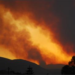
Forest Fires
Intentional fires get out of control and burn through the understory of nearby forests, burning small trees, vines, and shrubs. The dead and dying trees collapse, spilling firewood and kindling to the ground and affecting the forest canopy. In the past, thousands of deliberately set forest fires have raged out of control in Indonesia, Brazil, and Mexico, burning millions of acres of rainforest.
Climate Change
Changes in temperature and rainfall/snowfall affect the health of forests. Many trees in the Western U.S. are already suffering from climate change. With warmer, drier conditions in the region, pine trees are more likely to become infected with insects. These bugs bore into the trees and lay their eggs. Eventually, they kill the tree. Some forests in the West have lost over half their trees already to pine beetles. When the forest is gone, birds and small mammals that lived there have to find new homes--if they can.
Examples of Deforestation & Forest Disturbances
-
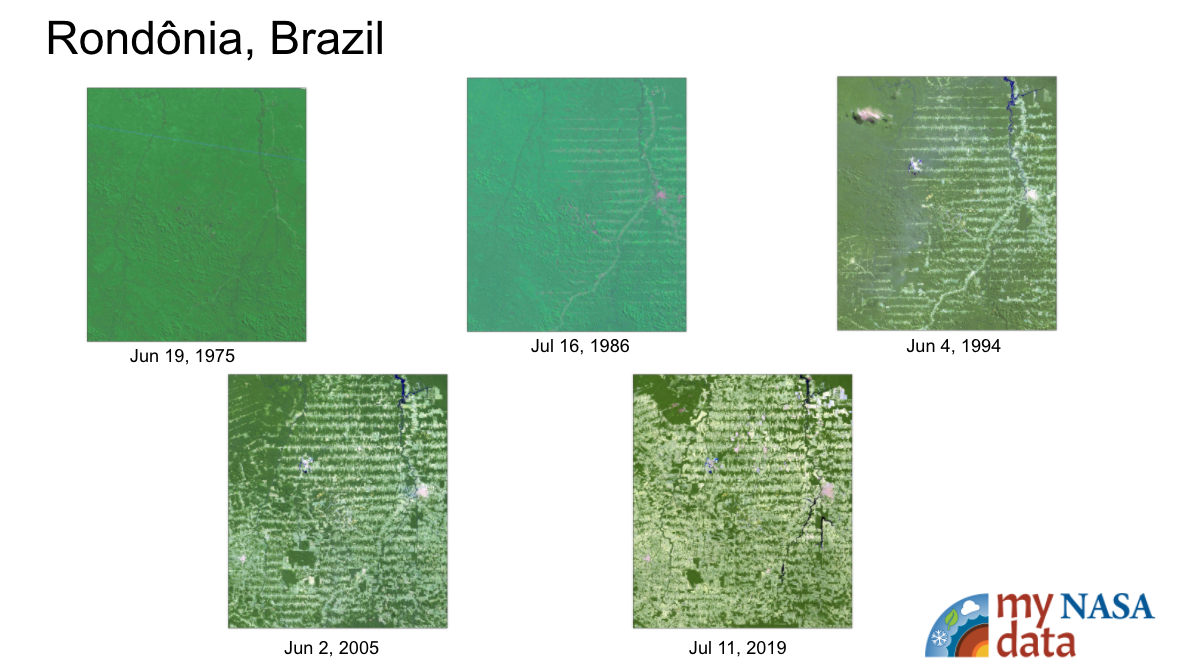
Rondônia in western Brazil
-
Peru
-
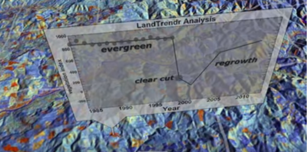
Southeast US & Brazil areas are analyzed by NAS Scientist.
American Association for the Advancement of Science (AAAS) Benchmarks
- Physical Setting/Processes that Shape the Earth/ Interdependence of Life; Use of Earth’s Resources; Weather and Climate (4C/M7) Human activities, such as reducing the amount of forest cover, increasing the amount and variety of chemicals released into the atmosphere, and intensive farming, have changed the earth’s land, oceans, and atmosphere. Some of these changes have decreased the capacity of the environment to support some life forms.
National Geographic Education Standards
- Standard 14: “Environmental modifications have economic, social, and political implications for most of the world’s people. Therefore, the geographically informed person must understand the reasons for and consequences of human modifications of the environment in different parts of the world.”
NASA supports and conducts research on tropical forests from space-based and ground-based perspectives, helping provide the information that national and international leaders need to develop strategies for sustaining human populations and preserving tropical forest biodiversity.
Measurements of global vegetation are valuable to scientists because they provide insight into the carbon cycle. Scientists use vegetation measurements to determine the planet’s net primary productivity: how much carbon is being used by the plants to grow. Carbon cycles through the oceans, soil and rocks, plants on land and in the ocean, and the atmosphere. The buildup of carbon dioxide released into the atmosphere by burning fossil fuel is the primary cause of global warming. The global biosphere has been helping to offset some of the excess carbon dioxide people have been pumping into the atmosphere.
- Standalone Lesson (no technology required)
- Internet Required
- One-to-One (tablet, laptop, or CPU)
Complementary Lesson Plans


Interactive Files
Grade Band
- 3-5
- 6-8
Time
- 50 minutes
Visualization Tool
NGSS Three Dimensional Learning
- See drop-down menu at the bottom of the page