Mini Lesson/Activity
Estimating Biomass Loss from a Large Fire
Overview
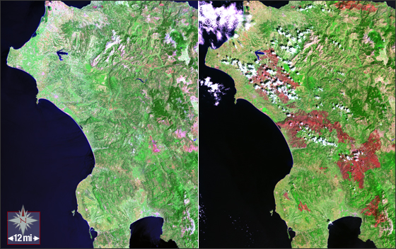
The fires in Greece during the summer of 2007 devastated large tracks of forest and ground cover in this Mediterranean region. Students analyze these data to determine the scale, area, and percentage of the forest impacted by of these fires.
Student Directions
Steps
- Use a paper copy of the image to complete this activity. Check with your instructor on how to submit answers.
- Using a metric ruler, and the conversion 1 mile = 1.61 kilometers, what is the scale of the image in meters per millimeter?
- About what is the total area, in square kilometers, of this photo of Greece and its surroundings?
- About what was the land area, in square kilometers, that was burned? (Burned areas show up in red in the image on the right.)
- What percentage of the total area was lost to the fires?
- Suppose that a typical forest in this region contains about 5.0 kilograms of biomass per square meter. How many metric tons of biomass were lost during the fires?

Image Credit: NASA/USGS Landsat
https://mynasadata.larc.nasa.gov/sites/default/files/inline-images/Greek_Fires_560.jpg
Sources:
- Image Credit: NASA/USGS Landsat
- Dunbar, Brian. “Earth Math Educator Guide.” NASA, NASA, 30 May 2013, https://www.nasa.gov/audience/foreducators/topnav/materials/listbytype/….
Teacher Note
Teachers, these mini lessons/student activities are perfect "warm up" tasks that can be used as a hook, bell ringer, exit slip, etc. They take less than a class period to complete. Learn more on the "My NASA Data What are Mini Lessons?" page.
Teachers who are interested in receiving the answer key, please complete the Teacher Key Request and Verification Form. We verify that requestors are teachers prior to sending access to the answer keys as we’ve had many students try to pass as teachers to gain access.
Disciplinary Core Ideas:
- ESS3B: Natural Hazards
Crosscutting Concepts:
- Scale, Proportion, and Quantity
Science and Engineering Practices:
- Analyzing and Interpreting Data
- Using Mathematics and Computational Thinking


