Lesson Plans
What’s Hot at the Mall?
Overview
In this investigation, "What's Hot at the Mall," students examine how shopping malls change natural environments. Studying NASA thermal images of a mall and its immediate surroundings introduces students to urban deforestation and to the formation of urban heat islands. Studying malls from an environmental perspective demonstrates the usefulness of geography in daily life and offers opportunities for direct observation and fieldwork. This investigation is modified from NASA's Mission Geography's Module 3: Human footprints on Earth as seen by NASA scientists for grades 5-8.
Materials Required
- Student Sheets: Briefings 1 and 2 and Logs 1, 2, and 3 (one copy per student)
- Student Sheets: Figures 1 and 2
- Student Sheet: Color copies of Figure 3
- Blank sheets of paper
- Overhead transparencies
- Markers
Optional:
- World Atlas
- Political map of the United States
- Road atlas of the United States
Procedure
Beginning the Investigation
1. Have students develop a list of topics that they think NASA scientists are studying. Share the list with the class. Discuss the topics and have students identify which topics are local issues and which are global issues.
2. Using the class discussion as a starting point, explain to students that NASA scientists study many topics and use photos and data gathered by airplanes as well as images and data gathered by satellites. Sometimes the topics that the NASA scientists study are very important to our local communities. One example is studying how land heats up when forest cover and other vegetation is removed and replaced by buildings and roads.
3. Open the discussion of shopping malls by asking students to write down some reasons why it is important to have convenient places to shop. List the reasons on the board or overhead transparency. Reasons may include:
- People have diverse needs and wants that are filled by buying goods and services.
- People like to go to nearby places to buy everyday items.
- It saves time to shop near one’s home or work.
- Places to shop should be easy to get to and easy to use.
- People like to save money getting from place to place.
Developing the Investigation
4. Provide a copy of Figure 1, the Huntsville day image, and ask students to identify the feature that is most likely a mall and to give some reasons for their answers. Ask them to speculate about other features on the image and to try to identify what they are. For example, they may mention forests, open land, major highways, residential areas, strip malls, movie theaters, and industrial areas.
5. Distribute Briefing 1 and have students read the Background, Objectives, and Procedures.
6. Distribute Log 1 and ask students to consider how the construction of a mall affects the surrounding environment. For example, malls sometimes replace ecosystems such as forests, wetlands, or open grasslands. These ecosystems provide habitats for wildlife and play an important role in pollution control. Have students identify what will happen to the environmental features listed in the Log when a mall is built.
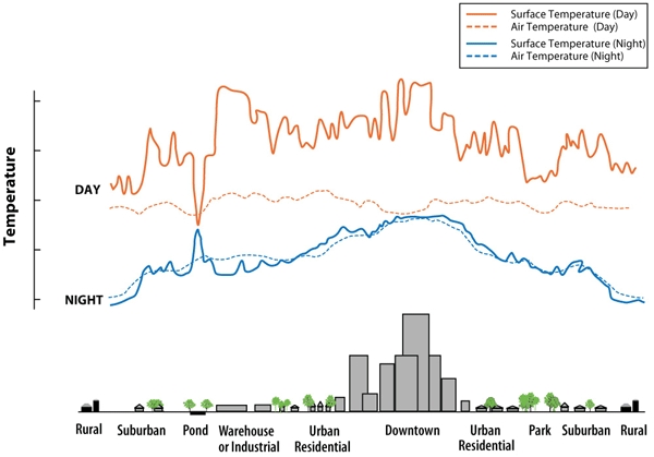
7. Distribute Log 2 and Figure 2. Ask students to examine the daytime thermal image of Huntsville. In the thermal image, warmer temperatures are represented by lighter shades of gray & white; the darker shades show cooler temperatures. Students should answer the questions in the Log.
Concluding the Investigation
8. Have students read the NASA research in Briefing 2. Distribute Log 3. Ask students to examine the thermal images of the tree in a parking lot and notice differences in the night and day temperatures around the tree.
Provide large sheets of paper and ask students to develop sketch maps (as described in Log 3) that show arrangements of trees that would more effectively cool a mall parking area.
As a final activity, if you have not already done this, have students discuss or write about the following questions:
- What are some of the major environmental impacts caused by a shopping mall?
- Would you want a new mall to be built across the street from your house? Why or why not?
Evaluation
Log 1
- An example is provided in the Log.
- Trees are cut down and other vegetation removed. A small amount of replacement vegetation is planted in landscaped areas around the mall.
- Some animals lose their habitats. They must move to other forested areas.
- Moving Earth material will alter the way that water flows. More sediment may enter streams due to erosion of disturbed land.
- Temperatures of air and land will sometimes increase due to heat retained and then released by pavement and buildings. This will warm the area.
Log 2
- Madison Square Mall parking lot
- Areas of tree cover in lower right of the image. Other tree-covered areas appear at top left and right of the image.
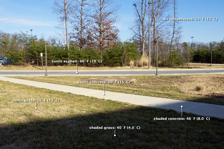
- The Sun’s rays cause paved areas and buildings to heat up. Trees and other vegetation help cool areas around the mall.
- Cool spots are indicated by the dark dots scattered around the mall parking lot. Trees are the cause of the dark dots and indicate cool spots.
- Parking areas around malls could be made cooler by planting more trees.
Disciplinary Core Ideas:
- ESS2D: Weather and Climate
Crosscutting Concepts:
- Cause and Effect
- Stability and Change
Science and Engineering Practices:
- Developing and Using Models
- Analyzing and Interpreting Data
In this investigation, students will
- identify topics that NASA scientists study;
- explain why NASA scientists are interested in studying malls;
- correctly identify a mall on the Huntsville, Alabama, thermal image;
- distinguish between hot and cool areas on thermal images; and
- explain some of the environmental consequences of constructing a shopping mall.
- How do human activities interact with other spheres in the Earth system?
- What are the impacts of these activities?
- How does NASA study environmental changes in the Earth system?
It is important for us to know how human activities influence the environment. Scientists use aerial photos, satellite images, maps, census data, and other information to examine land-use changes and the impact they have on the environment. Shopping malls and their surrounding areas provide excellent examples of temperature changes produced when trees and vegetation are replaced by buildings and pavement. There are intended and unintended environmental consequences when a shopping mall is constructed.
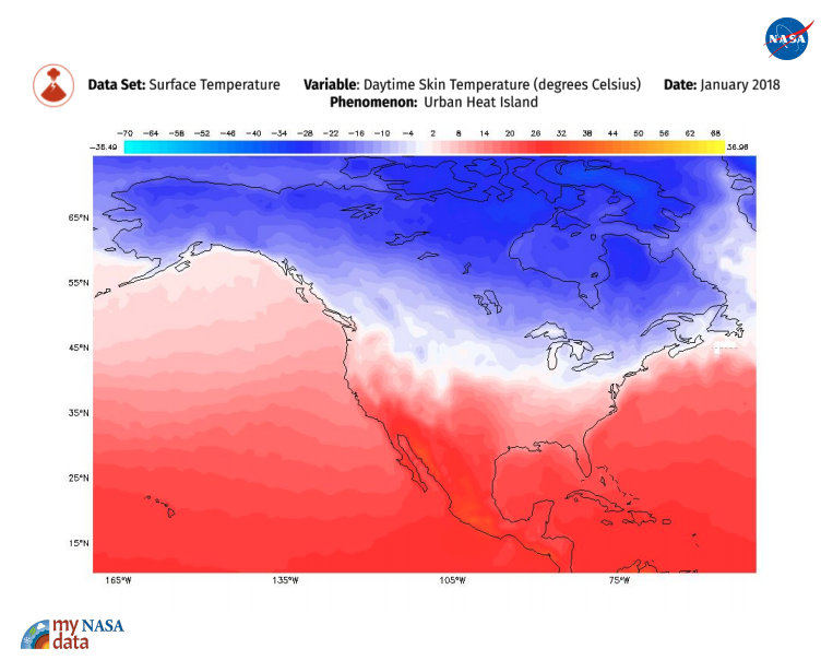
NASA uses an ATLAS imager to gather thermal images of parts of Earth’s surface. These images help scientists understand how the heat captured and then released by a city’s buildings and pavement coupled with the loss of trees and other vegetation affect local weather, air quality, and air and surface temperatures.
It is important for us to know how human activities influence the environment. Scientists use aerial photos, satellite images, maps, census data, and other information to examine land-use changes and the impact they have on the environment. For example, aerial photos and thermal measurements of an area in Huntsville, Alabama, are used in this investigation to study the effect of urbanization on surface temperatures. Interestingly, shopping malls and their surrounding areas provide excellent examples of temperature changes produced when trees and vegetation are replaced by buildings and pavement.
NASA collected the Huntsville images used in this investigation with ATLAS (Airborne Thermal/Visible Land Application Sensor), which sees in 15 colors, aboard a Lear 23 jet. The ATLAS imager scans and maps heat patterns in urban areas. ATLAS is the same basic instrument as the one onboard Galileo, an unmanned NASA spacecraft that orbited the planets Venus and Jupiter, and visited two asteroids.
Studying malls helps students to develop an ecological perspective by considering the environmental consequences of land-use change, in this case, the removal of vegetative cover and natural habitat. There are intended and unintended environmental consequences when a shopping mall is constructed. Intended consequences include the construction of roads and clearance of land to provide parking. Unintended consequences include the creation of traffic problems, absorption and consequent release of heat after sundown by large areas of pavement, and an increase in water pollution from oil and salt runoff from parking lots.
- Just as much sunlight falls on cities as on woodlands of the same size.
- Materials absorb and release heat differently.
- Human activity changes natural environments.
Misconception: Urban Heat Islands have a large effect on the global average air temperatures.
- Urban Heat Islands have only a small effect on the global average because cities cover only a small fraction of Earth’s surface.
Source: GLOBE
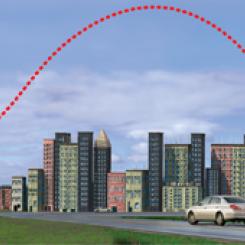
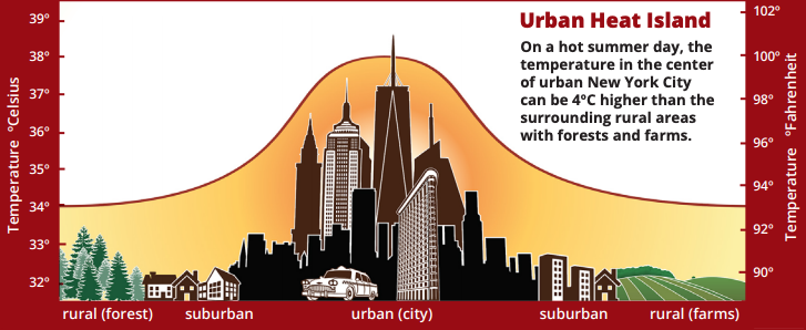
An urban heat island occurs when a city experiences much warmer temperatures than in nearby rural areas. Cities are full of rocky surfaces – asphalt, brick, and concrete – which increases the amount of energy from solar radiation they absorb. Urban areas often see temperatures rise 6°C (10°F) hotter than the surrounding suburbs and rural areas. These higher temperatures can cause people to become dehydrated or suffer from heat exhaustion.
NASA analyzes surface temperature data from around the world to better understand the characteristics of cities that drive the development of urban heat islands.
Atmospheric and Space Scientists – Investigate weather and climate-related phenomena to prepare weather and climate-related phenomena to prepare weather reports and forecasts for the public
Computer and Information Scientists – Conduct research in the field of computer and information science
Applications Software Developers – Develop and modify computer applications software that is used to communicate with satellites and people using satellite data
- Computer Programmers
- Systems Engineers
- Software Engineers
- Standalone Lesson (no technology required)
Complementary Lesson Plans
Complementary Mini Lessons
Complementary Pages


Grade Band
- 6-8
Time
- 90 minutes
Visualization Tool
NGSS Three Dimensional Learning
- See drop-down menu at the bottom of the page