Lesson Plans
Urban Heat Islands Implementation Sequence
Overview
The Urban Heat Island Implementation Sequence provides a series of lessons and activities for students to learn about the processes that create differences in surface temperatures, as well as how human activities have led to the creation of urban heat islands.
Materials Required
- Urban Heat Island Implementation Sequence
- Student materials will vary based on the selected lessons
Procedure
Teacher Directions:
The Implementation Sequence is a guide to get you started with teaching your students about the causes and effects of urban heat islands. The lessons listed are for a five-day series.
- You will find one activity for each day.
- Day 1: Mini Lesson- Analyzing Surface Temperature Differences
- Day 2: Mini Lesson- A Mini Urban Heat Island
- Day 3: Mini Lesson- Analyzing Surface Air Temperatures by Latitude
- Day 4: Mini Lesson - Relationship Between Surface Temperature and Vegetation
- Day 5: Interactive- Human Impact and the Creation of Urban Heat Islands
- The duration of the lessons varies from 30 to 50 minutes.
- The lessons include NGSS Disciplinary Core Ideas (DCIs), learning objectives, and activities/assessments.
- The sequence provides a list of additional resources for you to use as an extension or modification to your lessons.
- To view the sequence in its entirety, print the Urban Heat Island Implementation Sequence guide.
Disciplinary Core Ideas:
- ESS1A: The Universe and its Stars
- ESS1B: Earth and the Solar System
Crosscutting Concepts:
- Patterns
- Scale, Proportion, and Quantity
- Systems and System Models
Science and Engineering Practices:
- Developing and Using Models
- Analyzing and Interpreting Data
- Using Mathematics and Computational Thinking
- Engaging in Argument from Evidence
- Analyze surface air temperature anomalies to identify change with respect to different latitudes across the world
- Identify how climate has been altered before and after an event in different parts of the world by observing and analyzing different satellite images
- Analyze data collected on the energy transfer of different Earth materials
- What is the role of urban heat islands in Earth's energy balance?
- Why do different materials experience differences in surface temperature?
- What is the role of urban heat islands in Earth's energy balance?
- How has human activity led to the creation of urban heat islands?

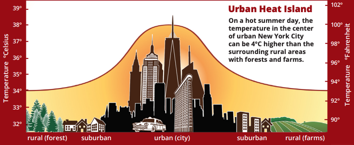
What Are Urban Heat Islands?
An urban heat island is a phenomenon that is best described when a city experiences much warmer temperatures than in nearby rural areas. The sun’s heat and light reach the city and the country in the same way. The difference in temperature between urban and less-developed rural areas has to do with how well the surfaces in each environment absorb and hold heat.
Where Do Urban Heat Islands Form?
The hottest places on Earth have a few traits in common. They are full of rock and stone, they do not have a lot of water, plants, or trees, and they are full of dark colors.
Cities are full of these rocky surfaces — asphalt, brick, and concrete — that absorb heat by day and release it at night. These materials are used to make the sidewalks, parking lots, roads, and basketball courts of urban areas. Urban heat islands form because humans replace cooler surfaces with rocky surfaces.
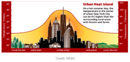
These hard and dark-colored surfaces contribute to the urban heat island effect in two ways. First, these surfaces have a low albedo, which increases the amount of energy from solar radiation they absorb. Second, these surfaces do not contain much water to evaporate, meaning that less of the absorbed energy evaporates water, and more goes into warming the surface and releasing energy by conduction, convection, or radiation. The combination of these factors means that cities and other highly developed areas are hotter than the plant-covered countryside.
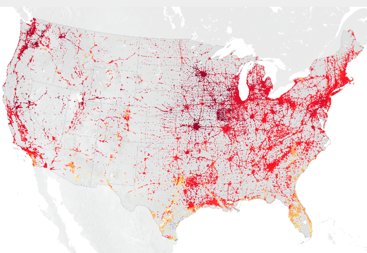
NASA analyzes surface temperature data from around the world to better understand the characteristics of cities that drive the development of urban heat islands.
- Internet Required