Lesson Plans
Create Your Own Soil Profile Activity
Overview
The purpose of this activity is for students to create a desktop soil profile based on the biome region of the United States where your school is located. They explore concepts of layering and different horizons of the soil, each having their own special characteristics.
Modified from Create Your Own Soil Profile Activity.
Materials Required
- clear glass vase with four sides
- rocks, dirt (based on biome type and soil horizons)
Procedure
- To engage students' prior knowledge, do K-W-L (K-What do you know about soil? and W- What do you want to learn about soil?). Have students brainstorm what they (think they) know about soil and any questions that they have. Discuss their ideas about soil with the class.
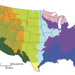
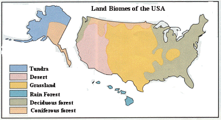
- Have students locate the land biome that best fits your school location by looking at the map in Figure 2. (For this activity, you will either be Desert, Forest, or Grassland. If you fall within the Tundra biome, please choose the next biome closest to you.) Discuss the physical characteristics of the biomes. For more information, visit the NASA Mission: Biomes.
Biomes
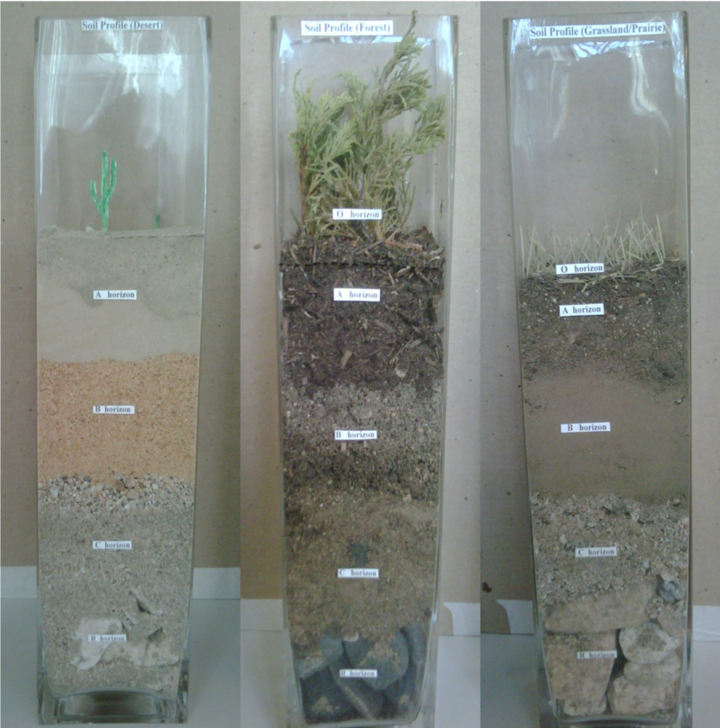
- Now, look at Figure 3 and match up your biome with the correct Soil Profile example.
- Write down which Horizons are part of you biome’s soil profile (this is very important, as the next step will be to collect soil samples from around your school and home that you can use to create your own soil profile.
5. Collect samples from around your school and home those rocks and soils that best fit your biome’s soil profile horizons.
6. For each sample, add them in layers to your vase and match them up to the examples in Figure 3.
7. Your Soil Profile will be complete after you add the final layer to your vase. Compare your soil profile to your classmates.
Discussion Questions:
1.) What do soil profiles tell us?
2.) What is a biome and what is the difference between a desert, forest, and grassland biome?
3.) What effect does the soil type have on the amount of soil moisture it can hold? How might you demonstrate this with your newly-created soil profile?
4.) What role does soil moisture play in the world’s climate?
5.) How will the SMAP mission help us better understand soil moisture? Please see http://smap.jpl.nasa.gov for more information.
Closing Activity
1. Return to the K-W-L (K-What do you know about soil? and W- What do you want to learn about soil?). Have students add the L Column to their sheet, What did you learn about soil?. Students record what they have learned about soil, as well as review the questions in Column 2, checking off any questions that they can now answer. They should also add new questions. Direct students to also review Column 1 so they can identify any misconceptions they may have held before beginning the lesson.
Disciplinary Core Ideas:
- ESS2A: Earth Materials and Systems
- ESS3A: Natural Resources
Crosscutting Concepts:
- Systems and System Models
Science and Engineering Practices:
- Developing and Using Models
- Planning and Carrying out Investigations
- Obtaining, Evaluating and Communicating Information
Students will:
- identify the biome that their school belongs to
- brainstorm key features of soil and biomes
- identify the matching horizon based on biome information
- collect samples for their community that fit their biome
- create a soil profile
- compare their soil profiles to others in their class.
- How does soil vary over the United States?
- Why do these differences occur?
- Why is soil important?
Soils are one of Earth’s essential natural resources, yet they are often taken for granted. Most people do not realize that soils are a living, breathing world supporting nearly all terrestrial life. Soils and the functions they play within an ecosystem vary greatly from one location to another as a result of many factors, including differences in climate, the animal and plant life living on them, the soil’s parent material, the position of the soil on the landscape, and the age of the soil.
Scientists, engineers, farmers, developers and other professionals consider a soil’s physical and chemical characteristics, moisture content and temperature to make decisions such as:
- Where is the best place to build a building?
- What types of crops will grow best in a particular field?
- Will the basement of a house flood when it rains?
- How can the quality of the groundwater in the area be improved?
Each area of soil on a landscape has unique characteristics. A vertical section at one location is called a soil profile. When we look closely at the properties of a soil profile, the story of the soil at that site and the formation of the area is revealed. The chapters of the soil story at any location are read in the layers of the soil profile. These layers are known as horizons. Soil horizons can be as thin as a few millimeters or thicker than a meter and the properties they contain that are different from the horizons above and below them. The formation of the soil profile mainly depends on parent rock material, climate, topography, and vegetation. Some soil horizons are formed as a result of the weathering of minerals and decomposition of organic materials that move down the soil profile over time. Other horizons may be formed by the disturbance of the soil profile from erosion, deposition, or biological activity. Soils may also have been altered by human activity. For example, builders compact soil, change its composition, move soil from one location to another, or replace horizons in a different order from their original formation. A typical soil profile takes nearly 1,000 to 100,000 years to form.
A soil profile comprises 5 major soil horizons (i.e., layers). They are the O, A, B, C and R horizons.
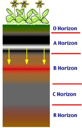
O Horizon: (1st layer) This is the top layer of soil. It is made of fresh to partially decomposed organic matter. The color varies from brown to black.
A Horizon: (2nd layer) The top part of this soil is made of highly decomposed, mixed up organic matter. The color ranges from brown to gray. This zone is also known as the root zone.
B Horizon: (3rd layer) Unlike the other horizons, this horizon has more clay and bedrock components. The higher clay content is due to leaching from the layers above. Some root activity also takes place in this layer.
C Horizon: (4th layer) This layer consists mostly of weathered bedrock. It is the cracked and broken surface of the bedrock.
R Horizon: (Last Layer) This is the last layer in the profile. It is made of unweathered rocks, the parent material.
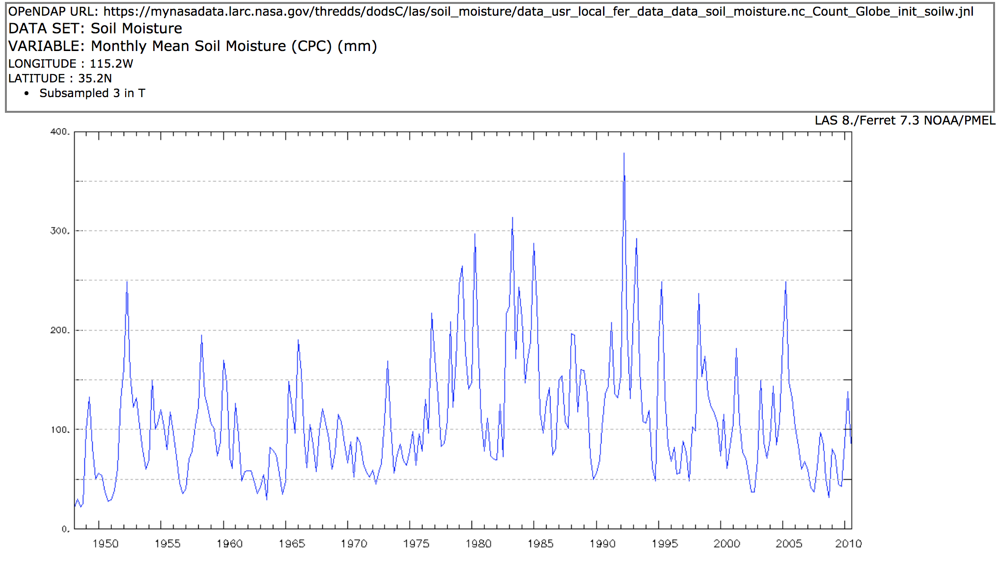
SMAP (Soil Moisture Active & Passive mission) measures the moisture content of the top ~5 cm of the soil profile. These surface layer measurements will be used in computer models to produce estimates of the soil moisture in the root zone, as well as estimates of evapotranspiration, infiltration/exfiltration, and recharge to groundwater. These quantities are greatly influenced by the characteristics of the soil profile.
-
Geoscientists - Research physical properties of the earth, such as rocks, soils, and other materials.
-
Soil and Plant Scientists - Explore the breeding, production, and management of crops, trees, and plants.
-
Conservation Scientists - Research, manage and protect natural resources like soil, forests, and water.
-
Atmospheric and Space Scientists - Investigate weather and climate-related phenomena to prepare weather reports and forecasts for the public
-
Earth Drillers, Except Oil and Gas - Explore minerals and soil properties through a variety of drilling and testing measures.
-
Agricultural Engineers - Solve problems that are related to the way farms work.
- Standalone Lesson (no technology required)