Lesson Plans
When Land Ice Melts
Overview
This activity invites students to model and observe the effect of melting ice sheets (from land) on sea level and the difference between the effect of melting sea-ice to that of melting land ice on sea level.
Credit: Modified from POLAR-PALOOZA (National Science Foundation under Grant No. 0632262) and the Office of Science, Department of Energy.
Materials Required
Materials: (for each team of 4 students)
- A large rectangular container
- Piece of wood (approximately 5 cm x 15 cm)
- Several trays of ice cubes
- Pitcher of water
Procedure
Engage
- Present the following question to students: Will the melting land ice add more water to the oceans and cause sea levels to rise? Ask students to write down or verbally respond. (The answer is yes.)
- The Arctic and Antarctic are covered with large sheets of ice. Other islands like New Zealand or Greenland have ice masses called glaciers covering the land. When land-based ice melts, more water flows into the sea, and sea level rises. However, the land previously covered by the ice, rises as well when the heavy load is removed. Icebergs in the ocean are broken off bits of land ice.
-
Distribute Student Data Sheet to each student.
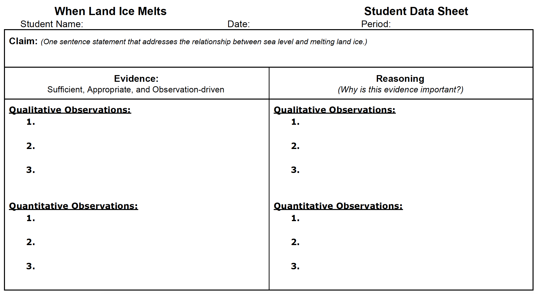
- Review the Claim section and have students develop one statement that addresses their prediction about the relationship between sea level and melting land ice.
Explore
- Distribute model materials to student teams of up to 4 students each.
- Step students through the Evidence section of the CER Model on the Student Data Sheet. Direct students to collect qualitative and quantitative data as they conduct the investigation.
- Next, review materials and procedure for developing the model.
- Procedure:
- On the surface of the wood, mark north, south, east, and west
- Going from north to south, draw line going east to west at 2-millimeter intervals
- Fill the container with water and place the wood in the water
- Put a couple of ice cubes on the N edge of the floating wood
- Watch and note the level of water in the container and on the N and S edges
- Document findings using qualitative and quantitative descriptions in the Evidence section of the Student Data Sheet
Explain
1. Present the video here and connect the concept of melting land ice and adding water to our oceans, using Greenland as an example. As students learn about the characteristics and dynamics of land ice, they should collect their ideas under the Reasoning section of the Student Data Sheet. They should connect the scientific ideas to any observations they make in the Evidence column.
2 Show students this animation and elicit students' ideas. Describe to students the connection among warming climate and oceans, and melting ice sheets and sea level.
Evaluate
- Have students share their CER models with the class. See rubric in Teacher Sheet for assessment.
- Review answers to the following questions:
- What happens to the north and south edges of the block of wood as the ice melts?
- Will melting glaciers and other land-based ice masses cause sea level to rise?
- Will it submerge the continents on which the ice used to be?
- Most of the world's tide gauges are on the edge of continents that in the recent geologic past had massive ice sheets on them. Can we get a good measure of trends in the world's sea levels from gauges if we do not properly consider the vertical land movements?
Disciplinary Core Ideas:
- PS4B: Electromagnetic Radiation
- ESS2A: Earth Materials and Systems
Crosscutting Concepts:
- Cause and Effect
- Systems and System Models
- Stability and Change
Science and Engineering Practices:
- Developing and Using Models
- Planning and Carrying out Investigations
- Engaging in Argument from Evidence
- Model what happens when ice sheets on land melt and the effect of sea level rise
- Compare the effects of melting sea and land ice
- How is land ice related to sea level change?
- How does land ice compare to sea ice in terms of contribution to sea level rise?
Sea level is rising, in part, because melting glaciers on land are adding more water to Earth’s oceans. Glaciers – large sheets of ice and snow – exist on land all year long. They are found in the mountains of every continent except Australia. Greenland and Antarctica contain giant ice sheets that are also considered glaciers. As temperatures rise, glaciers melt faster than they accumulate new snow. As these ice sheets and glaciers melt, the water eventually runs into the ocean, causing sea level to rise.
Icebergs and frozen seawater also melt in warm temperatures but do not cause sea level to rise. This is because they are already in the water. The volume of water they displace as ice is the same as the volume of water they add to the ocean when they melt. As a result, sea level does not rise when sea ice melts.
Another contributor to sea-level rise is the increase in volume that occurs when water is heated, called thermal expansion. Both thermal expansion and ice melt are the results of the rise in global average temperatures on land and sea known as climate change.
See "Warming seas and melting ice sheets" for more information.
The Greenland and Antarctic ice sheets have decreased in mass. Data from NASA's Gravity Recovery and Climate Experiment show Greenland lost an average of 286 billion tons of ice per year between 1993 and 2016, while Antarctica lost about 127 billion tons of ice per year during the same time period. The rate of Antarctica ice mass loss has tripled in the last decade.
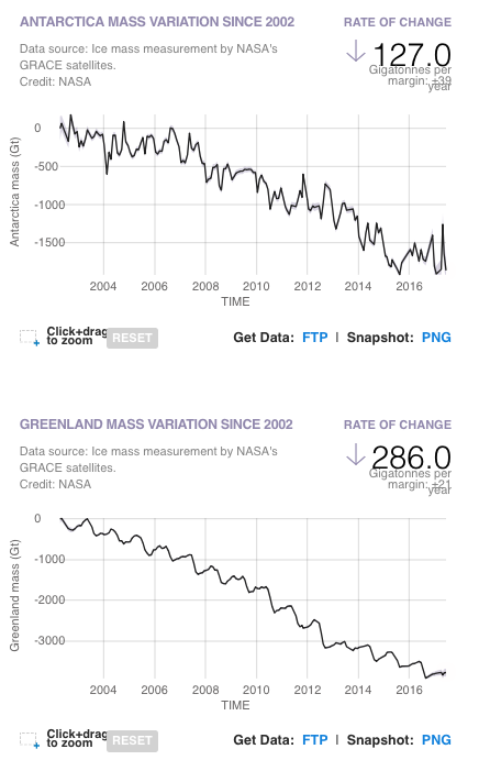
Data from NASA's GRACE satellites show ice loss in the land ice sheets in both Antarctica (upper chart) and Greenland (lower) since 2002. Both ice sheets have seen an acceleration of ice mass loss since 2009. (Source: GRACE satellite data)
Please note that the most recent data are from June 2017, when the GRACE mission concluded science operations. Users can expect new data from GRACE’s successor mission, GRACE Follow-On, in the summer of 2019.
- Teacher computer/projector only

