Lesson Plans
Ocean Impacts of an El Niño Event
Overview
Students will examine a 2014-2015 El Niño Southern Oscillation (ENSO) event to identify relationships among sea surface height, sea surface temperature, precipitation, and wind vectors. This activity employs a Jigsaw strategy where students analyze a single variable and then compare all four variables to analyze Earth System Essential Questions. In this process, students model the methods of researchers who connect their expertise with the broader community to study integrated science questions.
Materials Required
Per Student:
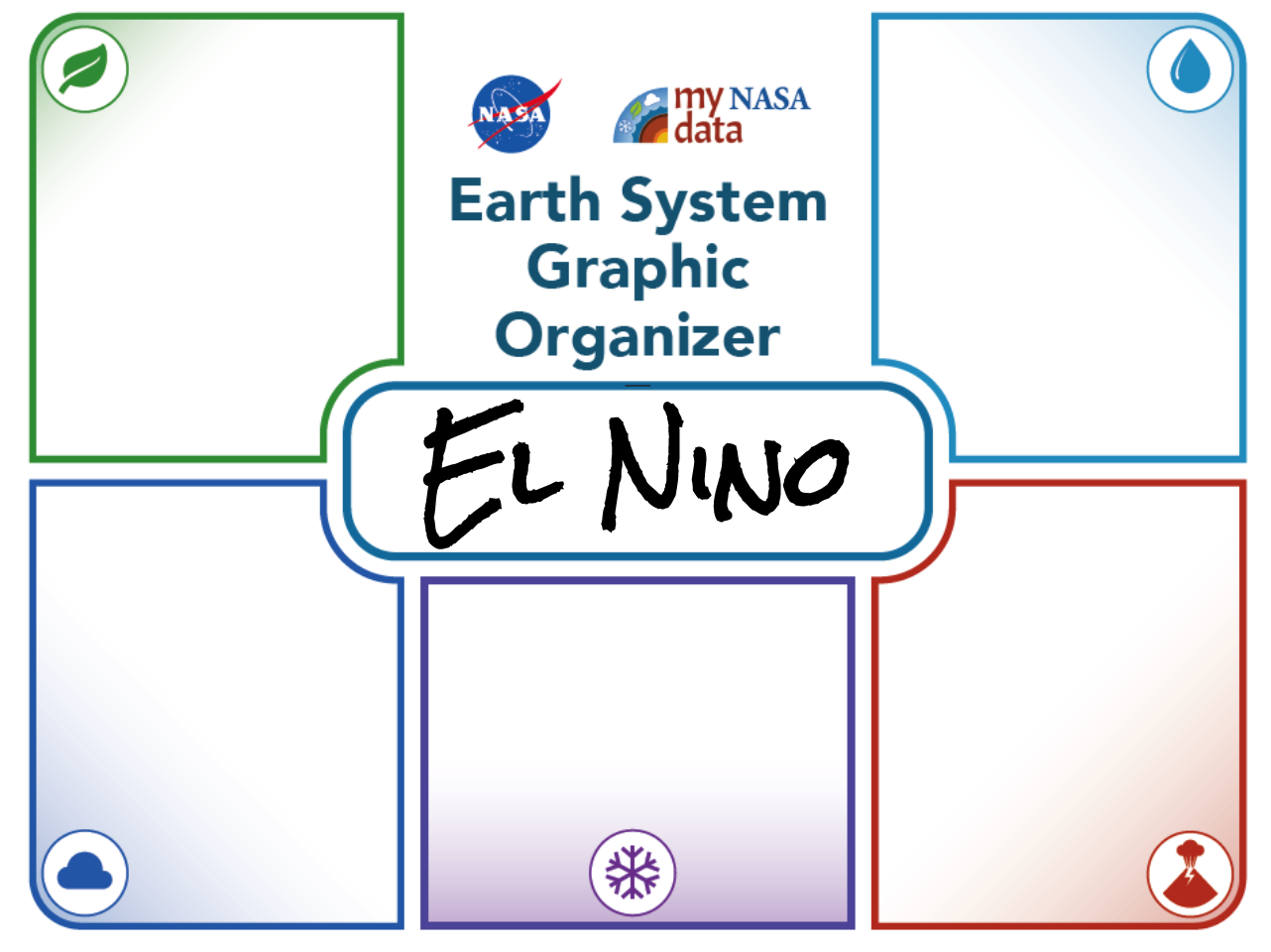
- Earth System Graphic Organizer
- NASA Blog Post: “El Niño can do some serious trash talking” By Laura Faye Tenenbaum https://climate.nasa.gov/blog/2338/
- Sticky notes
- Student Observation Sheet
- Student Observation Table
Per Group:
Student Data Sheets:
- El Niño Variable Data Overview
- El Niño Variable Data Plots:
- Wind Vectors
- Sea Surface Height Anomaly
- Sea Surface Temperature
- Precipitation
- El Niño Jigsaw Rubric
Procedure
Part 1: Search for Connections to the Earth System
-
Display/distribute the NASA blog post, “El Niño can do some serious trash talking” by Laura Faye Tenenbaum, about the effects of El Niño on a California community and have students look for connections to the Earth System to prime students for exploring the phenomenon of El Niño .
-
Distribute the Earth System Graphic Organizer for students to record their ideas of ways that the spheres of the Earth System are affected in this California community. Review the sections of the graphic organizer with the students.
Part 2: Explore ENSO Through Jigsaw Activity
1. Divide all students into Variable Teams (six to seven students), as well as Jigsaw Groups (four to five students) depending on class size.
Background on The Jigsaw Teaching Strategy:
The jigsaw activity is a cooperative learning technique wherein each student in a group becomes an expert on one particular part of a topic, El Niño in this case. The technique works by placing students into jigsaw groups. Each jigsaw group is responsible for researching and reporting back on a Driving Question related to El Niño . Each student in the group is also assigned a science variable (as part of the Variable Team) to research, therefore every member of the class is essential as the groups need each student in order to fully understand the topic. The students research their variable of the El Niño phenomenon and get together into “expert” teams composed of the students from the other Jigsaw Groups who are also responsible for the same variable. The Variable Teams share and discuss what they learn about their variable. Finally, students go back to their Jigsaw Groups and report back on what they learned about their how their variable addresses their Driving Question. In order to have a complete picture, the group must understand the contributions of each student in the group.
2. Set the stage for learning by telling students that they will first work within their Jigsaw Groups to review their assigned Driving Question. They are responsible for taking a true systems approach to researching this question and teaching the class about the answer at the end with one presentation slide for their Driving Question. Each member is expected to communicate an aspect of their research using evidence and reasoning from their Variable Team research.
Each Jigsaw Group will focus on a specific Driving Question. Teacher to assign the questions to the different groups.
- How does a change in the Atmosphere of the Earth System affect the Hydrosphere? Vice Versa.
- How is the energy transferred among the various spheres of the Earth System?
- How is matter shared within the various spheres of the Earth System?
- What other parts of the Earth System may experience the effects of El Niño and how?
- What phenomena are associated with changes in different spheres of the Earth System? What variables appear to be correlated?
3. Provide about five minutes for students to meet with their Jigsaw Group and discuss what the Driving Question means, what thoughts that they have before looking at the data, what kinds of data and changes to anticipate, additional questions, etc.
- The final product of this activity will consist of a Jigsaw group presentation that answers the assigned Driving Question using evidence and reasoning of the science variables collected by each individual in the group. Present the rubric to the teams.
- Assure that the Jigsaw Groups that there will be a time, in the end, to come back together to prepare their product.
4. Next, divide students into their Variable Teams. Distribute (or project) the El Niño Variable Data Plots Overview and Variable data maps/visualizations for 2014 & 2015. Review the variables, their units, and scale with students. Have students observe scale (including color bar scale and wind vector lengths). Note: for the Wind Vector group, draw students’ attention to the slight variations among the scales throughout the year. Together, members of the Variable Team will observe data related to the specific variable over time and complete the Student Observation Table and Question Sheet.
Variable Teams will research the following science parameters:
- Wind Vectors
- Sea Surface Height Anomaly
- Sea Surface Temperature
- Precipitation
5. Teacher models data analysis using one variable while guiding students observations'. First, start with qualitative analysis. For example, note how the data values (color changes) over the course of a year with the students. Next, model for students quantitative analysis by having students locate (20°N, 150°E) on the map and estimate the data values for that region. Students will document this value on the Student Observation Table. Engage students in making observations and asking questions on the modeled data set.
6. Provide about 20-25 minutes for students to collaborate in their Variable Team to make observations in the Student Observation Table; students may choose to complete the entire table independently, or work as a team to subdivide the work based on a latitude or longitude. Next, the team answers questions on the Student Observation Sheet: Variable Team. Note: This aspect can be completed for homework.
7. Now, students return to their Jigsaw Groups and share their data. Students begin addressing their Driving Question and communicate their ideas to the class using evidence and reasoning. Together, they complete the Student Observation Sheet: Jigsaw Group addressing their assigned Driving Question.
8. Provide students with approximately 20 minutes to prepare their presentation and 3-5 minutes to present their information.
Part 3: Explain their Findings
Students share their findings to the class. This could be through a presentation slide, through a concept map, etc.
Disciplinary Core Ideas:
- ESS2A: Earth Materials and Systems
- ESS2C: The Role of Water in Earth’s Surface Processes
- ESS2D: Weather and Climate
Crosscutting Concepts:
- Cause and Effect
- Systems and System Models
- Stability and Change
Science and Engineering Practices:
- Asking Questions and Defining Problems
- Developing and Using Models
- Analyzing and Interpreting Data
- Engaging in Argument from Evidence
- analyze a sequence of plots over time for different variables for changes
- correlate changing variables that contribute to the El Niño phenomenon
- communicate arguments based on evidence
- How does a change of energy in one sphere of the Earth System affect another sphere?
- How the energy transferred among the various spheres of the Earth System?
- How is matter shared within the various spheres of the Earth System?
- What other parts of the Earth System may experience the effects of El Niño and how?
- What phenomena are associated with changes in different spheres of the Earth System? What variables appear to be correlated?
See NASA's El Niño: Pacific Wind and Current Changes Bring Warm, Wild Weather
https://earthobservatory.nasa.gov/features/ElNino
- Ability to read a map
- Ability to identify a specific point using latitude and longitude values
National Geography Standards:
- 8th Grade 7.1: The physical processes that shape the patterns of Earth's surface: The four components of Earth’s physical systems (the atmosphere, biosphere, hydrosphere, and lithosphere) are interdependent
- 8th Grade 8.2: Characteristics and Geographic Distribution of Ecosystems: Physical processes determine the characteristics of ecosystems
- 8th Grade 14.3: How human actions modify the physical environment: The physical environment can both accommodate and be endangered by human activities
- 12th Grade 7.1: The physical processes that shape the patterns of Earth's surface: The interactions of Earth's physical systems (the atmosphere, biosphere, hydrosphere, and lithosphere) vary across space and time.
- 12th Grade 14.1: How human actions modify the physical environment: Human modifications of the physical environment can have significant global impacts.
Weather and climate change through complex links between the oceans and the atmosphere. Sources of variability in weather and climate around the world are changes in water currents, atmospheric pressure, and temperature in the oceans, especially the Pacific Ocean. These changes in the Pacific are often referred to as the El Niño Southern Oscillation, or ENSO. If you want to understand how interconnected our planet is—how patterns and events in one place can affect life half a world away—study the ENSO phenomenon.
Two types of changes are referred to as El Niño and La Niña. This lesson focuses on El Niño which is a condition that sometimes occurs in the Pacific Ocean, but it is so big that it affects weather all over the world. NASA works with the National Oceanic and Atmospheric Administration (NOAA) and other scientific institutions to track and study ENSO in many ways. From underwater floats that measure conditions in the depths of the Pacific to satellites that observe sea surface heights and the winds high above it, scientists now have many tools to better understand ENSO events.
Although El Niño events are complex and evolve differently—as do their impacts and connections—improved predictions would help communities to prepare for likely impacts and to minimize disruptions. With more advanced warning, resource managers and civic leaders could make adjustments to how they manage fisheries, which crops to plant, what resources to allocate to combating mosquitoes, and when to raise awareness of risks such as fire or mudslides. The United Nations (U.N.) Office for the Coordination of Humanitarian Affairs reported in April 2016 that 60 million people across Africa, Asia, the Pacific, and Latin America needed food assistance due to weather extremes from the 2015-16 El Niño. Looking back at 1997-98, the U.N. attributed more than 20,000 deaths and $36 billion in infrastructure damage to that El Niño. With the help of NASA and others, an improved understanding of this event may help mitigate these losses.
- Physical oceanographer - This scientist researches waves, tides, currents, transmission of light and sound in the ocean, and ocean-atmosphere relationships
- Biological oceanographer - This researcher studies marine life forms and their relationships to each other and the environment
- Meteorologists - Professionals who are involved with researching, teaching, consulting, and forecasting weather, climate, and the forces that cause change in our environment.
Opportunities for Advanced Learners
-
El Niños are known to have local and global effects. Use the My NASA Data Earth System Data Explorer (ESDE) (https://larc-mynasadata-2df7cce0.projects.earthengine.app/view/earth-system-data-explorer) to study the effects of El Niño in your region. Check out: Hydrosphere/All Data/Sea Surface Properties/ Daily Sea Surface Temperature & Sea Level (Sea Surface Height) Anomaly, Hydrosphere/All Data/Precipitation/Monthly Precipitation, as well as Atmosphere/All Data/Wind Speed & Vectors/Vectors/Monthly Near-Surface Wind Vectors. Historical ENSO events were recorded in the following years. Note: (ESDE will not feature data for all of these historic dates.)
- 1790–93
- 1828
- 1876–78
- 1891
- 1925–26
- 1972–73
- 1982–83
- 1997–98
- 2002–03
- 2004–05
- 2006–07
- 2009–10
- 2014–16
-
La Nina is the opposite of El Niño . Check out this video on the connection between El Niño and La Nina (https://youtu.be/wVlfyhs64IY). Use the My NASA Data Earth System Data Explorer (ESDE) (https://larc-mynasadata-2df7cce0.projects.earthengine.app/view/earth-system-data-explorer) to study the characteristics of a La Nina. (See #1 above for recommended variables.) Historical La Nina events were recorded in the following years. Note: (ESDE will not feature data for all of these historic dates.)
- 1904
- 1908
- 1910
- 1916
- 1924
- 1928
- 1938
- 1949–51
- 1954–56
- 1964
- 1970–72
- 1973–76
- 1983–85
- 1988–89
- 1995–96
- 1998–2001
- 2007–08
- 2008–09
- 2010–12
- 2016–17
- 2017-18
-
Explore the social and economic implications of an El Niño event from a social studies perspective. Check out these resources:
- NASA Examines Global Impacts of the 2015 El Niño
- NASA Examines El Niño's Impact on Ocean’s Food Source
- El Niño Brought Drought and Fire to Indonesia
- Internet Required
- Teacher computer/projector only
Complementary Lesson Plans
Grade Band
- 6-8
- 9-12
Time
- > 90 minutes
Visualization Tool
NGSS Three Dimensional Learning
- See drop-down menu at the bottom of the page