Lesson Plans
SPHERES OF EARTH: An Introduction to Making Observations of Earth Using an Earth System Science Approach
Overview
This activity introduces students to aspects of the atmosphere, biosphere, hydrosphere, and litho/geosphere and how they are interrelated. It is designed to promote an interest in authentic investigations of Earth using images acquired by astronauts as the hook.
This activity is designed to promote an interest in authentic investigations of Earth with a general understanding of Earth System Science. The activity uses the 5-E model of instruction which is an inquiry-based learning approach. The use of images acquired by astronauts of Earth is used as a hook for potential future student investigations.
The Spheres of Earth Student Guide is designed to include activity sheets and text to allow students to rely less on the teacher for information and instruction, and more on themselves as independent learners. You are encouraged to review information with students to ensure understanding of concepts and instructions.
Materials Required
• Computer lab for students to explore Gateway to Astronaut Photography of Earth website (http://eol.jsc.nasa.gov)
OR printed Spheres of Earth Image Resource Set
- Spheres of Earth Student Guide
- Spheres of Earth Teacher Guide
- Projector (optional)
- Spheres of Earth Quick Reference Sheet (optional)
Other Useful Materials & Resources
- World map, or Google Earth or NASA World Wind, if available, to increase students knowledge of the geography of the Earth
- Individual Student Sheets are provided at the end of this Teacher Guide for printing as desired

Disciplinary Core Ideas:
- ESS1C: The History of Planet Earth
Crosscutting Concepts:
- Systems and System Models
Science and Engineering Practices:
- Asking Questions and Defining Problems
- Developing and Using Models
- Planning and Carrying out Investigations
- Constructing Explanations and Designing Solutions
- Engaging in Argument from Evidence
- Obtaining, Evaluating and Communicating Information
Students will:
- Be introduced to, and become familiar with, the relationship among different Earth systems.
- Identify and associate visible features on Earth with “spheres” or systems of Earth.
- Understand remote sensing terminology associated with studying imagery from space.
This activity is designed to be used for multiple purposes. It can be used as a stand-alone activity introducing students to an Earth System Science approach to studying Earth. It can also be used as an introductory activity to students participating in the Expedition Earth and Beyond Program. The activity allows students to explore and discover visible features in astronaut photography acquired from space. There is a database of over 900,000 images available for students to view images from space, available at the Gateway to Astronaut Photography of Earth website, http://eol.jsc.nasa.gov. This activity provides a framework in which to have students observe our Earth from the unique perspective of space and teach objectives and standards you may be required to cover. Students will have a rich authentic experience of looking at NASA images in which they will identify features associated with the different Spheres of Earth (Earth Systems). Additionally, they will gain insight into the process of science. The activity builds on students’ prior knowledge about Earth and takes them through a process where they can recognize visible features of Earth, associate those features with an Earth system, and consider how changes in one system/feature may cause a change in another.
Our home planet, Earth, is the launch pad for learning and understanding other bodies in our Solar System. Our Earth System is made up of 4 major components. Those are the atmosphere, hydrosphere, biosphere and litho/geosphere. Most school textbooks likely use the lithosphere as the term used for studying the “rocks” and geologic processes. Since the 1960’s however, and the study of plate tectonics, the term “geosphere” has been becoming more widely used in the scientific community to refer to what has traditionally been referred to as the lithosphere. For this activity, we will use the term litho/geosphere to enable you, as teachers, to parallel concepts traditionally taught without fear that the term geosphere is not a part of your standard curriculum. We also hope to have you and your students ahead of the curve with what current science has moved towards, that may or may not yet be reflected in your books or curriculum. Keep in mind there is no one correct way to divide up Earth’s systems. For example, you may find that some scientists make reference to the cryosphere when they refer to water in the Earth’s surface where water is in solid (ice) form. Others may include other spheres such as the magnetosphere, for example. For the purposes of this activity, we will divide up the components of Earth’s systems as the atmosphere, hydrosphere, biosphere and litho/geosphere.
By using an Earth System Science approach, scientists, and your students are able to understand that our Earth is made up of a set of systems that are all interrelated. It is similar to the human body system, which is referred to in Part 1 of the activity. All human body systems work together to maintain a healthy body that functions properly. In terms of Earth System Science, each of those systems allows Earth to keep itself in balance. A change in one system will affect other systems. Changes may be subtle, but with careful observation and critical thinking skills, students will be able to understand an introductory connection between the systems.
Features listed and associated with a system in this activity are not all-inclusive. Additionally, there are certain features that may be considered a feature related to more than one system. For example, clouds are listed within the atmosphere system of Earth. They could, however, be listed under the hydrosphere system of Earth as clouds are small droplets of water in the liquid or solid state suspended in the atmosphere. Likewise, let’s think about glaciers. Thinking of glaciers as mere masses of ice and studying that ice might lead you to identify the hydrosphere as the main system related to glaciers. Looking at glaciers as a geologic feature or focusing on glacial processes and how they shape the surface would be more related to the litho/geosphere. Students can scientifically debate (argue!) their justification of a feature being most closely associated with one system versus another. As long as they can justify the association based on the explanation of the Earth system and its association to that feature, there may or may not be a wrong classification. Justification is key.
The following information, also listed in the student guide, provides a breakdown of the four major systems or spheres of Earth, and features associated with those systems that can be studied using astronaut photography. Again, this is not an all-inclusive list of features but does provide a good list to use to help students understand the different systems and features. Keywords related to each system are in bold italics to help reinforce important information.
1. Atmosphere: This sphere relates to meteorological features and phenomena such as weather, clouds, or aerosols (particles in the air). It includes an ever-changing mixture of gas and small particles located above and surrounding the Earth’s surface. Features include:
- Clouds
- Hurricanes and Cyclones Aurora
- Air Pollution/Aerosols
- Dust and Sand Storms
2. Biosphere: This sphere is associated with living systems such as biomes or ecosystems. This includes life on land, in the oceans and rivers, and even life we cannot see with the naked eye. Features visible in astronaut photographs include:
- Coastal Biomes -Forests -Deserts
- Grasslands -Urban/Agricultural Ecosystems
3. Hydrosphere: This sphere is associated with water in solid (ice) and liquid states. Water in a gas state (water vapor) is probably best considered as a feature of the atmosphere. Features include:
- Oceans -Lakes and Rivers -Snow
- Ice Bergs -Glaciers
4. Litho/Geosphere: This sphere is associated with solid portions of the Earth. It includes rocks, sediments and soils, surface landforms and the processes that shape the surface. Features associated with this system can be broken down into a variety of different processes. These are:
- Fluvial and Alluvial Processes: Deltas, river channels/canyons, alluvial fans
- Aeolian Processes: Sand dunes, yardangs, wind streaks
- Tectonic Processes: Folds, faults, mountains
- Volcanic Processes: Volcanoes, central vents, volcanic deposits
- Impact Processes: Impact craters
- Other Processes: Mass wasting processes, erosional processes
Most images will include features that can be associated with more than one Earth system. This reinforces the idea that together these systems make up our Earth today and changes to any system or feature will also have an effect on what our Earth will be like in the future.
Crew Earth Observations – Astronaut Photography
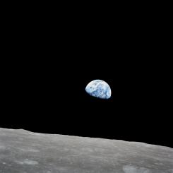
Astronauts onboard the International Space Station (ISS) are asked to take images of our Earth as part of their science activities. Scientists at the Image Science and Analysis Laboratory (ISAL) at the NASA Johnson Space Center train the astronauts to identify features from orbit and also help provide scientific context to the need for this data. While on the ISS, astronauts are sent task lists with images to acquire while on orbit. Images are acquired using hand-held digital cameras that are onboard the ISS. These off-the-shelf cameras and a variety of lenses allow astronauts to capture images of Earth from the unique perspective of space and at varying resolutions. Currently, the Nikon D2 and D3 series cameras are being used. Other cameras that have been used by astronauts (on both the shuttle and ISS) are the digital Kodak DCS760, as well as film cameras such as the Hasselblad 70mm camera, which was used early on. Images from space have been acquired by astronauts since the 1960’s during the Mercury missions. The quality of the images has improved with camera technology and with the use of different focal length lenses. By changing the focal length of the lens, astronauts are able to acquire images that have a wider or narrower field of view. The higher the focal length (800mm for example) the narrower the field of view (less area will be covered). Higher focal lengths allow greater detail of the surface to be revealed but less surface area is covered. Lower focal lengths allow a larger area to be imaged, but the details of the surface will not be as crisp. The scientific need for the image drives the focal length that is requested. Sometimes astronauts take images of Earth just to reveal its beauty from space. These images allow all of us here on Earth to enjoy the wonder and beauty of our planet.
The Gateway to Astronaut Photography of Earth website (http://eol.jsc.nasa.gov) houses the database of these 900,000+ images that have been acquired by astronauts. There are many ways to search for images. This activity has students make observations of images found in the Weekly Top 10 list. The images listed here can change so it is important to make sure students use the provided observation logs to record their data. These log sheets are important for students to get accustomed to, as any science investigation or experiment requires logging data. The metadata students are asked to record will help them to sort through the variety of information that is provided for every image. As students become familiar with how to find this basic metadata, it will help them if they choose to conduct a research project using astronaut photography.
Oftentimes there are captions written for images on the website. These captions can be very useful to provide background information. It is important to have students read, or at least skim this information to help them understand the image they are observing as well as help them as they look at other images. The more they observe and read, the more they will transfer that knowledge when examining other images. There is also a link listed that states, “Download a Keyhole Markup Language (KML) file for use in Google Earth.” If you have Google Earth on your computer, clicking on this link will take you to a view of the location on Earth shown in the image. This provides a greater context for the image and its location. This will assist your students in learning geography of Earth, as well as the importance of context when trying to understand what is going on in an image.
Included below are examples of two astronaut photographs and information about some of the visible features and their associated Earth System. Additionally, there is information to help relate how a change to one features/sphere could cause a change in others. The images shown here include labeled features to help you identify the features being listed. Not all images on the Gateway to Astronaut Photography of Earth website include images with labeled features.
- Standalone Lesson (no technology required)
- Internet Required
- One-to-One (tablet, laptop, or CPU)
- Teacher computer/projector only