GLOBE Connections
GLOBE Connections: Ocean Circulation Patterns
GLOBE protocols and learning activities that complement the Ocean Circulation Patterns phenomenon through hands-on investigations are detailed below. Students can conduct their own investigations and see how their data relate to global circulation patterns by using GLOBE and My NASA Data together.
Visit the GLOBE Hydrosphere Protocols & Related ESDE Datasets page that outlines the datasets available in the Earth System Data Explorer. These data complement student GLOBE investigations using the following protocols.
Ocean Circulation Patterns
Protocols
GLOBE protocols are used to collect data and explore the conditions related to El Niño, as well as share their data with other GLOBE students around the world. The protocols below were used in at least one phase of the recent GLOBE ENSO Campaign
Salinity Protocol - Students will use a hydrometer to measure the specific gravity of the water sample, and use a thermometer to measure the temperature. With these two values, students will use tables to determine the salinity.
Water Temperature - Students will measure the temperature of water.
Protocol Bundle
The ocean protocol bundles can complement explorations of ocean circulation.
Ocean Protocol Bundle - Oceans are complex ecosystems, which implies that their study needs to take into consideration several interrelated physical parameters, not to mention the mechanisms and processes which reflect the interaction between land and oceans along coastal zones as well as the interaction between the atmosphere and oceans. This group of protocols is to be jointly implemented to improve our knowledge about oceans.
Learning Activities
El Niño and La Niña are important climatic phenomena that impact the climate globally causing flooding and droughts, as well as changes in seasonal weather. These three learning activities will prepare students for collecting data and support the integration of MND with GLOBE in your curriculum.
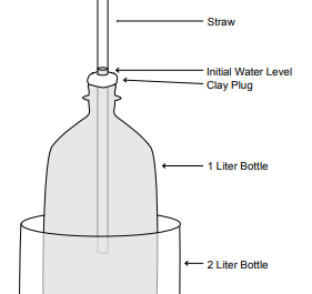
Overview: Students will construct a soda-bottle thermometer, which is similar to the thermometer used by GLOBE schools. Both are based on the principle that most substances expand and contract as their temperature changes. This experiment also demonstrates the principle of heat transfer.
Student Outcomes:
- The student will understand why and how a standard thermometer works.
- Substances expand and contract as they are heated and cooled.
The temperature variability of a location affects the characteristics of the physical geographic system.
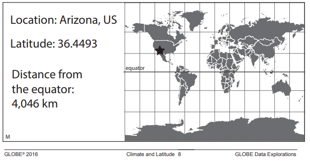
Climate and Latitude - A GLOBE Data Exploration ![]()
Overview: Students investigate GLOBE air temperature data from five locations and deduce the origin location of each dataset after learning the relationship between distance from the equator and temperature.
Student Outcomes:
- Match graphs of temperature data with locations given the latitude
- Explain why they matched each graph to a particular location using the knowledge that seasonal differences are larger further from the equator and temperatures are warmer near the equator
- Weather can be described with quantitative measurements
- Weather changes day to day and over seasons
How Do Seasonal Temperature Patterns Vary Among Different Regions of the World?
![]()
![]()
![]()
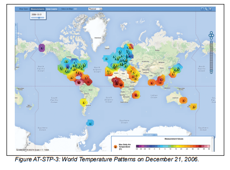
Overview: Students use the GLOBE Student Data Archive and visualizations to display current temperatures on a map of the world. They explore the patterns in the temperature map, looking especially for differences between the Northern and Southern Hemispheres, and between equatorial regions and high latitudes. Then students zoom in for a closer look at a region that has a high density of student reporting stations (such as the US and Europe). They examine temperature maps for the region, from four dates during the past year (the solstices and equinoxes). Students compare and contrast the patterns in these maps, looking for seasonal patterns. At the end of the activity, students discuss the relative merits of different types of data displays: data tables, graphs, and maps.
Student Outcomes:
- Summarize the effect of latitude, elevation, and geography on global temperature patterns
- Explore local and regional seasonal variations
- Heat energy is transferred by conduction, convection, and radiation
- Heat moves from warmer to colder objects
- Sun is a major source of energy for changes on the Earth’s surface
- Weather changes from day to day and over the seasons
- Seasons result from variations in solar insolation resulting from the tilt of the Earth’s rotation axis
- The sun is the major source of energy at Earth’s surface
- Solar insolation drives atmospheric and ocean circulation
- Sunlight is the major source of energy for ecosystems
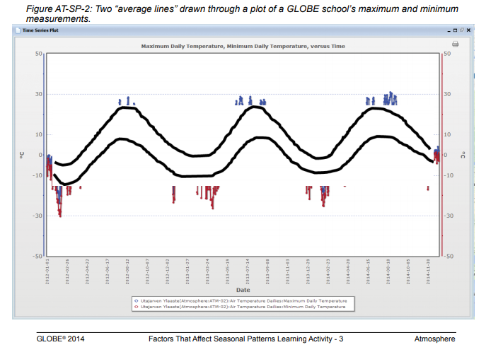
What Are Some Factors that Affect Seasonal Patterns? ![]()
Overview: Students analyze the graph of the past year’s maximum and minimum temperatures at their site. They compare this graph to similar graphs for two other sites - one nearby and one distant. They list factors that might cause the patterns to be different, and select one to investigate in depth. They repeat this process with other parameters. Students summarize their investigations by describing how latitude, geography and elevation influence seasonal patterns.
Student Outcomes:
- Interpret a graph of annual temperature data
- Identify factors that account for temperature pattern differences
- Compare temperature patterns on a regional basis
- Heat energy is transferred by conduction, convection, and radiation
- Heat moves from warmer to colder objects
- Sun is a major source of energy for changes on Earth’s surface
- Weather changes from day to day and over the seasons
- Seasons result from variations in solar insolation resulting from the tilt of the Earth’s rotation axis
- The sun is the major source of energy at Earth’s surface
- Solar insolation drives atmospheric and ocean circulation
- Sunlight is the major source of energy for ecosystems
- Energy for life derives mainly from the sun
- Living systems require a continuous input of energy to maintain their chemical and physical organizations
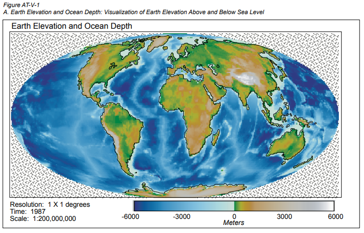
Learning to Use Visualizations ![]()
Overview: In this learning activity, students use visualizations to make sense of elevation and temperature data and to explore the relationships between the two variables. Students color in visualizations of elevation and temperature so that important patterns in the data become evident. The relationship between the two quantities is studied by using them to compute the lapse rate, the rate at which temperature falls with increasing elevation.
Student Outcomes:
- Students identify and communicate important patterns in a data set by drawing a visualization and begin to interpret those patterns
- Students analyze the correlation between two variables using visualization as a tool
Getting to Know Your Satellite Imagery and GLOBE Study Site
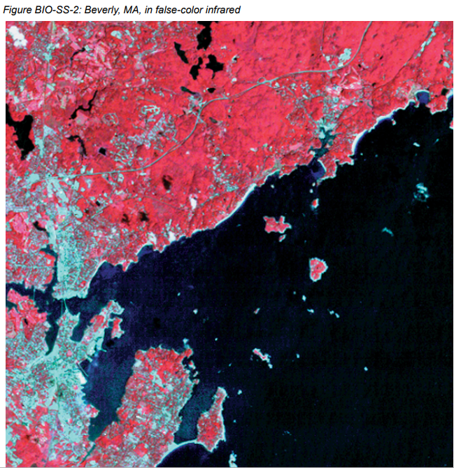
Overview: Students outline and label areas in their school’s Landsat TM image to create a simple land cover map. They use this map to locate areas for field study.
Student Outcomes:
- How to use maps (real and imaginary)
- The physical characteristics of a place
- The characteristics and distribution of ecosystems
Overview: Students will construct a 3-dimensional model of a catchment basin. They will use the model to explore catchment basins, water pathways, and manipulate the model to illustrate how catchment basins can change.
Student Outcomes:
- Define the concept of a catchment basin and a watershed
- Give examples of how their model relates to the real world
- Give examples of basic concepts of catchment basins and watersheds, such as, water runs downhill, hills make divides, low-lying areas create pooling, water quality is affected by what is upstream
- Soils have properties of color, texture and composition; they support the growth of many kinds of plants
- Landforms are the result of destructive and constructive forces
- Soils consist of weathered rocks and decomposed organic matter
- Water circulates through the biosphere, lithosphere, atmosphere and hydrosphere (water cycle)
- Water is a solvent
- Each element moves among different reservoirs (biosphere, lithosphere, atmosphere, hydrosphere)
Overview: Students will study and visit the Hydrosphere Study Site, conduct a visual survey to discover information about local land cover, water quality, and document their findings. They will use this initial investigation to raise questions about local land cover and/ or water chemistry issues that may require further investigation.
Student Outcomes:
- Students will learn different methods for finding out about a study site, such as through library research, field visits, and interviews
- Soils have properties of color, texture and composition; they support the growth of many kinds of plants
- Landforms are the result of destructive and constructive forces
- Soils consist of weathered rocks and decomposed organic matter
- Water circulates through the biosphere, lithosphere, atmosphere and hydrosphere (water cycle)
- Water is a solvent
- Each element moves among different reservoirs (biosphere, lithosphere, atmosphere, hydrosphere)
- Organisms can only survive in environments where their needs are met
- Earth has many different environments that support different combinations of organisms
- Organisms change the environment in which they live
- Humans can change natural environments
- All organisms must be able to obtain and use resources while living in a constantly changing environment


Sphere(s)
- Hydrosphere