Lesson Plans
How to Calculate Sea Ice Changes Videos
Overview
This series of videos highlights how NASA Climate Scientists use mathematics to solve everyday problems. These educational videos to illustrate how math is used in satellite data analysis. The videos, filmed at NASA’s Goddard Space Flight Center in Greenbelt, Maryland, feature senior climate scientist Claire Parkinson. In the videos, Parkinson explains how the Arctic and Antarctic sea ice covers are measured from satellite data and how math is used to determine trends in the data.
“These videos are for people interested in understanding something about how scientists use satellite data to learn about changes in the Earth system, especially changes in sea ice coverage,” Parkinson said.
Procedure
Video 1: Calculating Sea Ice Coverage
Key ideas:
- Percent aerial coverage of sea ice (A.K.A. sea ice concentration)
- Line graphs (plots) of the percent of sea ice over seasonal cycles.
Video 2: Determining Trends in Yearly Average Sea Ice Extents
Key ideas:
- Use plots to interpret trends to ask how has sea ice has changed over time
- Create yearly averages
- Apply linear least squares fit line (best fit line)
Video 3: Determining Trends in Sea Ice Extent Monthly Derivations
Key ideas:
- Create monthly deviations to a single cycle of data
- Plot data positive and negative values
Disciplinary Core Ideas:
- ESS2A: Earth Materials and Systems
Crosscutting Concepts:
- Scale, Proportion, and Quantity
- Stability and Change
Science and Engineering Practices:
- Asking Questions and Defining Problems
- Developing and Using Models
- Analyzing and Interpreting Data
- Using Mathematics and Computational Thinking
- This video showcases how scientists use percents and line plots to interpret distribution of sea ice.
- How do scientists know that sea ice has changed?
- How does sea ice change over the seasons throughout the year?
- How does sea ice change over the scale of years?
- How is math used as a tool to understand these patterns?
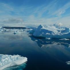
NASA controls more than 17 Earth-observing satellites. Some collect data about sea ice coverage in various areas around the world. Scientists use this information to compare the ice covers over time and to calculate trends.
“The satellite data have given us a tremendous record of sea ice changes since the late 1970s,” Parkinson said. “In the Arctic, sea ice coverage has declined significantly; but in the Antarctic, sea ice coverage has actually increased somewhat, although by much less than the decreases in the Arctic.”
Parkinson said math is not only used to analyze sea ice concentrations. “One of the amazing aspects of math is how widely it can be applied,” she said. “The same techniques shown in the videos for sea ice coverage can be used in all sorts of applications, not just in Earth sciences but in a wide range of studies.”
Parkinson has been a climatologist at Goddard for 36 years. She authored a number of books on climate and developed a computer model of sea ice. Parkinson primarily researches polar sea ice and how the changes in sea ice relate to broader issues of global climate change.
- Teacher computer/projector only