Interactive Models
Exploring Patterns of Human Geography and COVID-19
Overview
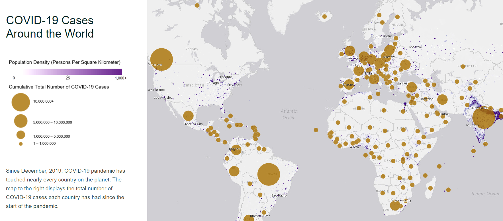
Using interactive maps of COVID-19 cases and population density, students will describe how the spread of COVID-19 is affected by population density and explain why patterns in the spread of COVID-19 are happening over time.
This interactive model is one of a two-part sequence of learning experiences related to COVID-19. To maximize optimal learning outcomes, it is suggested to complete the series in the following order:
- Exploring Patterns of Human Geography and COVID-19 Interactive Model (current page)
- Stability and Change of COVID-19 and Nitrogen Dioxide Interactive Model
Teacher Note
![]()
Learning Objectives
- Students will describe how the spread of COVID-19 is affected by population density.
- Students will explain why patterns in the spread of COVID-19 are happening over time.
Essential Questions
- What factors influence the spread of COVID-19?
- How is the spread of COVID-19 affected by human behavior?
- How do we quantitatively describe and compare countries' total COVID-19 cases?
Materials Required
- Computer/Tablet
- Internet Access
- Google Form (optional)
- Link to Exploring Patterns of Human Geography and COVID-19 Interactive Model
Teacher Answer Key
Teachers who are interested in receiving the answer key, please complete the Teacher Key Request and Verification Form. We verify that requestors are teachers prior to sending access to the answer keys as we’ve had many students try to pass as teachers to gain access.
Supported NGSS Performance Expectations
- MS-LS1-5: Construct a scientific explanation based on evidence for how environmental and genetic factors influence the growth of organisms.
- MS-LS2-1: Analyze and interpret data to provide evidence for the effects of resource availability on organisms and populations of organisms in an ecosystem.
- MS-LS2-4: Construct an argument supported by empirical evidence that changes to physical or biological components of an ecosystem affect populations.
- HS-ESS3-6: Use a computational representation to illustrate the relationships among Earth systems and how those relationships are being modified due to human activity.
Complementary Models

Interactive Files
Grade Band
- 6-8
- 9-12
Time
- 30 minutes