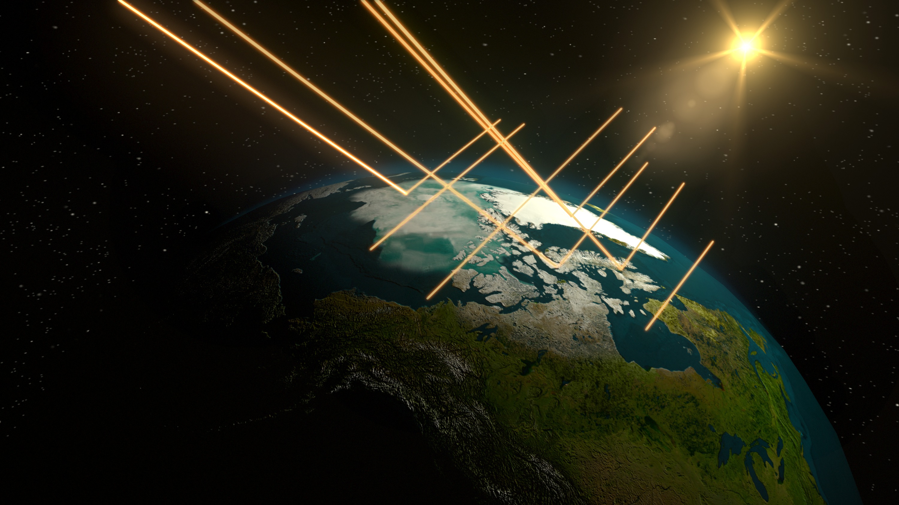
When sunlight reaches the Earth’s surface, some of it is absorbed and some is reflected. The relative amount (ratio) of light that a surface reflects compared to the total incoming sunlight is called albedo. A surface with a high albedo will reflect more sunlight than a surface with low albedo. Surfaces with high albedos include sand, snow and ice, and some urban surfaces, such as concrete or light-colored stone. Surfaces with low albedos include forests, the ocean, and some urban surfaces, such as asphalt.
Albedo generally applies to visible light, although it may involve some of the infrared region of the electromagnetic spectrum. You understand the concept of low albedo intuitively when you avoid walking barefoot on blacktop on a hot summer day. Blacktop has a much lower albedo than concrete because the black surface absorbs more energy and reflects very little energy.
Albedo is a non-dimensional, unitless quantity that indicates how well a surface reflects solar energy. Albedo varies between 0 and 1. Albedo commonly refers to the "whiteness" of a surface, with 0 meaning black and 1 meaning white. A value of 0 means the surface is a "perfect absorber" that absorbs all incoming energy. Absorbed solar energy can be used to heat the surface, evaporate water, or, when sea ice or snow is present, melt the surface. A value of 1 means the surface is a "perfect reflector" that reflects all incoming energy.
Albedo is important to Earth scientists because it plays a significant role in our planet’s average surface temperature. When a surface reflects incoming sunlight, it sends the energy back to space, where it doesn’t affect temperature or climate.
Earth's Energy Budget Includes Albedo
The albedo of areas on Earth will affect the amount of solar energy absorbed. Therefore, Earth's energy budget can be affected by snow and ice cover, seasonal vegetation and land-use changes which change surfaces. See how these changes can affect albedo.
When do albedo values change?
Seasonal Changes in Earth's Surface Albedo
The flow of energy in the Arctic is heavily influenced by the seasons. In this section, we will learn why seasons in the Arctic are so much different than other locations on Earth.
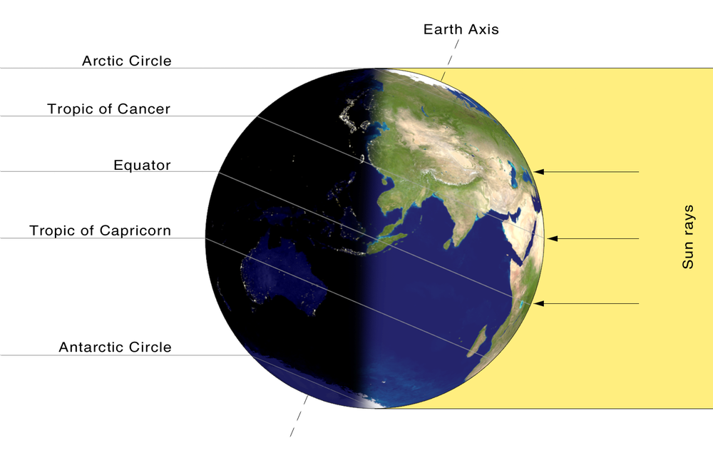
First of all, we experience day and night because the Earth is always rotating upon its axis, but Earth’s axis is actually tilted at an angle of 23.5 degrees. As Earth orbits the sun, its tilted axis always points in the same direction. Throughout the year, different parts of Earth get the sun’s direct rays.
So, when the North Pole tilts toward the Sun, it’s summer in the Northern Hemisphere. And when the South Pole tilts toward the Sun, it’s winter in the Northern Hemisphere.
Image Credit: Przemyslaw "Blueshade" Idzkiewicz, NASA
About 50 million square kilometers of the Earth's terrestrial surface undergo a transition each year from freeze to thaw, thus setting off a series of processes in the global biosphere. Much of this activity can be detected by the changes over time in the amount of sunlight reflected by the Earth's surface at various wavelengths. A quantitative measure of this reflected sunlight is described by the albedo, which is the fraction of sunlight reflected by a surface area to that incident on the surface area in all directions, typically in a given spectral band. The surface albedo can vary between zero (all incident sunlight is absorbed at the surface and none is reflected) and one (all incident sunlight is reflected from the surface and none is absorbed). Fresh snow is an example of a surface type with an albedo close to one in the visible region of the solar spectrum whereas deep clean ocean water has an albedo that is close to zero.
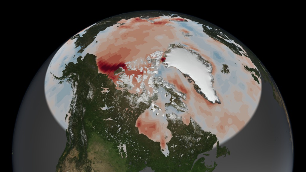
Five years of global surface albedo data are now available as summary maps from NASA's Multi-angle Imaging SpectroRadiometer (MISR). The globes in the image show a particular kind of albedo, formally known as Directional Hemispherical Reflectance (DHR), in which all scattering effects from the atmosphere are removed. Thus the sunlight incident on any part of the global surface is uniquely directional, coming only from the location of the sun in the sky and with no sunlight created by scattering in the atmosphere. The first and third line of globes show MISR blue, green, and red band DHR, combined to create a natural color DHR. These images show what color the surface would be after taking out the effects of clouds and scattering. Brighter areas of white and brown have a higher albedo that darker areas of green and blue. The second and fourth line of globes show DHR-PAR, that DHR for the sunlight band containing only those wavelengths used in photosynthesis (400 - 700 nanometers), which are absorbed by vegetation. The sunlight in this spectral region is known as photosynthetically active radiation (PAR), thus the label DHR-PAR for the associated albedo. A heavily vegetated surface area will therefore have a small DHR-PAR value (blue on the color scale) while non-vegetated areas where absorption is small in the PAR region will tend to have high values of DHR-PAR (green to red on the color scale). Regions where DHR or DHR-PAR could not be derived, either due to an inability to retrieve the necessary atmospheric characteristics or due to the presence of clouds, are shown in black.
MISR Imagery - Seasonal Changes in Albedo - Credit: Image credit: NASA/GSFC/LaRC/JPL, MISR Team.
The globes cover most of Asia, eastern Europe and the Middle East, for each of the four seasons in the years 2003 and 2004. Noteworthy differences between the years 2003 and 2004 include increased albedo over the Gobi Desert region during September to November of 2004, compared with this interval in 2003. Surface albedo changes occur naturally on a seasonal and annual basis, but albedo is also sensitive to perturbations such as land use changes. Albedo maps constitute an important dataset in climate studies, particularly climate modeling. Combined with solar exposure estimates, they are also useful in agricultural research (e.g., estimation of crop yields and disease outbreaks) and land management. Global MISR DHR maps are also available for all other parts of the planet, and for monthly as well as seasonal time increments. These and other surface and vegetation products from the MISR instrument are available from the MISR instrument are available from the NASA Langley Atmospheric Sciences Data Center's MISR Level 3 Imagery web site.
The Multi-angle Imaging SpectroRadiometer observes the daylit Earth continuously from pole to pole, and every 9 days views the entire globe between 82 degrees north and 82 degrees south latitude. MISR was built and is managed by NASA's Jet Propulsion Laboratory, Pasadena, CA, for NASA's Office of Earth Science, Washington, DC. The Terra satellite is managed by NASA's Goddard Space Flight Center, Greenbelt, MD. JPL is a division of the California Institute of Technology.
Text acknowledgment: John Martonchik (Jet Propulsion Laboratory) and Clare Averill (Raytheon ITSS/Jet Propulsion Laboratory).
Polar Day and Night Cycles
Because of the Earth’s axial tilt, the Arctic Circle sees dramatic day/night cycles depending on the season. The animation shows how certain areas of the earth receive more day or night time depending on the season.
Video: NASA On Air: A Reason For The Seasons
Credit: NASA's Scientific Visualization Studio
Read about the day and night cycle near the North Pole and then replay the animation and see if you can spot these changes.
Winter:
The Winter is the darkest time of year near the North Pole. There has been no sunlight or even twilight since early October. This darkness lasts until early March.
Spring:
Starting in March, the sun will begin to rise higher in the sky with each advancing day. Locations near the North Pole begin to experience daytime and nighttime hours.
Summer:
Beginning in June, locations near the North Pole will now experience only sunlight throughout the summer because it is pointed towards the sun.
Autumn:
In September, the sun will begin to lower in the sky. Daytime hours will decrease and nighttime hours will increase until early October when locations near the North Pole experiences full darkness again.
Why does NASA study albedo?
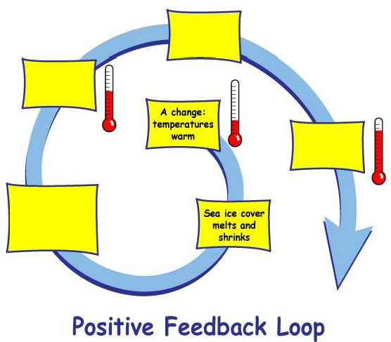
As mentioned above, albedo is important for Earth's energy budget and climate modeling. The impact of changing albedo contributes to stronger warming trends in the Arctic. This is because the warming causes sea ice melt which lowers the albedo of the Arctic. When the albedo is lowered, more solar energy is absorbed leading to even more warming. This is called positive feedbackand is illustrated by the video.
Albedo also impacts urban heat islands. An urban heat island occurs when a city experiences much warmer temperatures than in nearby rural areas. Cities are full of rocky surfaces – asphalt, brick, and concrete – which increases the amount of energy from solar radiation they absorb. Urban areas often see temperatures rise 6°C (10°F) hotter than the surrounding suburbs and rural areas. These higher temperatures can cause people to become dehydrated or suffer from heat exhaustion.
NASA analyzes surface temperature data from around the world to better understand the characteristics of cities that drive the development of urban heat islands.